Discover the hidden landscapes and indigenous heritage of rural Quebec
Most travelers stick to the St. Lawrence River, but if you push inland, you hit a part of Quebec that feels like it belongs on another planet.
Beyond the St. Lawrence: Uncovering Quebec’s Untamed Interior
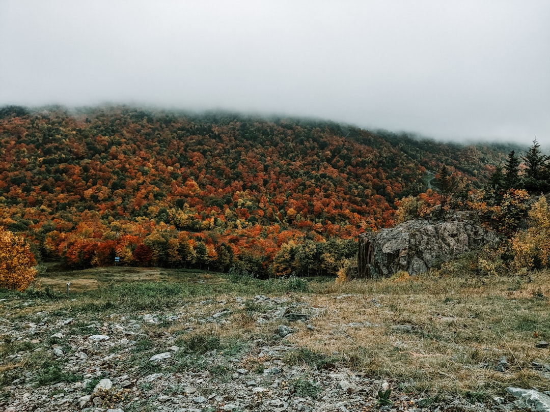
Most travelers stick to the St. Lawrence River, but if you push inland, you hit a part of Quebec that feels like it belongs on another planet. Think about the Caniapiscau Reservoir, for example; it covers over 4,000 square kilometers, which technically makes it one of the largest artificial lakes anywhere, yet you rarely hear about it in standard travel guides. The geology here is just wild, especially when you consider the Torngat Mountains at the northern tip, where the rocks are nearly 3.9 billion years old. You’re literally walking on the oldest ground on Earth. It’s a complete contrast to the manicured streets of Quebec City or Montreal, and honestly, that’s exactly why it’s worth the effort to see it for yourself.
If you head toward the Ungava Peninsula, you’ll find the Pingualuit Crater, a 1.4-million-year-old impact site that holds some of the purest water you’ll ever encounter because it’s so cut off from the rest of the world. I find it fascinating how this remote interior operates on its own terms, from the way permafrost releases ancient methane in the summer to the way the Magnetic North pole’s drift causes local geomagnetic anomalies. You’ve also got the Innu and Naskapi nations, who have navigated these plateaus for over 5,000 years, leaving behind archaeological traces that tell a much older story than what you’ll find in the history books. It’s not just scenery; it’s a living, breathing record of human and geological history.
The biology up there is just as tough as the landscape, with the George River caribou herd once roaming a range of 600,000 square kilometers, which is just massive when you think about it. Even with a growing season that barely lasts two months, the interior peatlands act as a carbon sink holding 1.5 billion metric tons of carbon, which makes the region pretty important for the planet's climate math. I was looking at some recent aerial surveys from last year that mapped out entirely new eskers—those long, winding glacial ridges—and it really proves that we still don’t know everything about this terrain. It’s rugged, it’s isolated, and it’s arguably the most honest version of Canada you can find. If you’re looking for a trip that actually changes how you view the map, this is the place to start.
Honoring First Nations: A Deep Dive into Indigenous Traditions
When we think about exploring Quebec’s vast interior, it’s easy to focus solely on the sheer scale of the wilderness, but honestly, the real story here is the people who have called this land home for millennia. Let’s pause for a moment and reflect on the fact that we’re often just guests in a landscape shaped by thousands of years of stewardship, not just geology. The Wendat language, for instance, was once feared lost, but through a dedicated effort to digitize 17th-century manuscripts, it’s seeing a comeback that feels nothing short of heroic. It’s wild to think that while we’re busy tracking glacial ridges, the Innu and Naskapi nations have maintained oral archives that accurately map post-glacial landscape shifts, like the drainage of ancient lakes, which align perfectly with what modern geologists are finding today.
You really have to appreciate how this isn't just history—it's a living, breathing set of survival and management practices that we’re only just beginning to grasp. Think about the way these communities have used controlled burning to create mosaic habitats that naturally boost berry yields and support local wildlife populations; it’s a level of ecological engineering that makes our modern conservation efforts look pretty basic by comparison. I find it fascinating that their traditional diet, rooted in local flora and fauna, creates a unique gut biome diversity that you just don't see in urban settings. Even their approach to technology is clever, like the use of birch bark, which is basically nature’s own hydrophobic, antimicrobial packing material.
If you’re looking at it from a research perspective, there’s a clear shift happening where traditional knowledge is finally being integrated with modern data to actually get things done. We’re seeing satellite telemetry being paired with Indigenous expertise on caribou migration, and honestly, the precision this creates is lightyears ahead of what we could do alone. It’s also worth noting how their cosmology defines land rights not as ownership, but as a reciprocal responsibility—a philosophy that’s increasingly relevant as we try to figure out how to manage these northern ecosystems for the long haul. Whether it's the pharmacological potential of Labrador tea or the stellar navigation charts that elders have passed down, there’s a depth to this heritage that challenges everything we think we know about the north. It’s not just about seeing the sights; it’s about recognizing that this land is a sophisticated, historical record that we’re lucky to be learning from.
Traversing the Boreal Forest: Landscapes Beyond the Tourist Trail
If you’ve ever felt like the typical highway routes just skim the surface of a place, you’re not alone, and that’s why I want to talk about the boreal interior of Quebec. It’s not just a collection of trees; it’s a massive natural filter where thick carpets of sphagnum moss hold up to twenty times their dry weight in water, effectively acting as the region’s hydrological stabilizer. When you step off the beaten path, you’re walking over vast lichen mats that survive brutal minus forty-degree winters by entering a state of cryptobiosis, a dormant miracle of biology that most hikers never get to witness. I find it fascinating that hidden deep within these spruce stands, the rare ghost orchid skips photosynthesis entirely, relying instead on a subterranean fungus to feed it. It’s a stark, quiet kind of beauty that reminds you how much life is happening just below the surface.
If you head further into the interior, you’ll encounter palsa mounds—these strange, peat-covered permafrost formations that literally rise and fall as ice lenses beneath the ground freeze and thaw. Think about the resilience required here; the black spruce trees have evolved serotinous cones that stay locked tight for years, only popping open to release seeds when the intense heat of a forest fire forces them to. It’s an aggressive, beautiful cycle of renewal. I’ve noticed the microclimates here are surprisingly stable, with the dense canopy keeping the forest floor five degrees warmer than the exposed tundra during the peak of winter. You’ll also see those tea-colored lakes everywhere, which are naturally acidic because of all the organic carbon leaching from the decaying needles on the forest floor.
Let’s be honest, the scale of this place is hard to wrap your head around, especially when you realize it contains the highest concentration of undammed rivers on the planet. These waterways keep natural thermal regimes intact, which is the only reason those landlocked salmon populations haven’t vanished yet. You might even hear a frost quake while you're out there, which sounds exactly like a rifle shot when water deep in the soil freezes and cracks the ground wide open. It’s a bit jarring, but it’s just the landscape shifting in real-time. During the summer, the midnight sun turns the forest into a metabolic hotspot, and you’ll see the blue haze of volatile organic compounds hanging over the treeline, a reminder that this forest is literally breathing and interacting with the atmosphere in ways we’re only just starting to map.
Communing with the Land: Authentic Indigenous-Led Experiences
When we talk about communing with the land, it’s easy to get caught up in the romanticism of the wilderness, but honestly, the real value lies in the technical brilliance of Indigenous-led experiences. I’ve found that these aren't just tours; they’re masterclasses in survival and ecological management that have been refined over thousands of years. Take the trapper’s trail, for instance, where family-held lines demonstrate a level of sustainable harvesting that puts modern commercial resource management to shame. It’s fascinating to see how elders use the lunar calendar of the woods to time their harvests with pinpoint precision, aligning human activity perfectly with the natural recovery cycles of the region. When you're out there, you aren't just walking through a forest; you're learning to read the landscape through methods like sign-cutting, where flattened vegetation and snapped twigs reveal the age and direction of wildlife movement with surprising clarity.
Beyond the navigation, there’s an incredible depth of traditional chemistry and engineering that really changes how you look at the natural world. I’m always struck by the construction of shaputuan longhouses, which feature sophisticated ventilation systems that allow for indoor fire pits without a hint of smoke buildup—a design feat that challenges our own reliance on modern HVAC. You might spend an afternoon learning about the pharmacological potential of willow bark, which is a natural source of salicin, or discovering how Cree and Innu preservation techniques like fat-sealing keep food safe from microbes for months. Even something as simple as the medicine wheel takes on a new meaning when you realize it’s actually a practical management tool for balancing human impact against the land’s capacity to regenerate. It’s a level of sophistication that makes our standard Leave No Trace principles feel like an entry-level framework.
If you’re the kind of person who wants to see how this all connects, look at how these communities use star-mapping to track animal migrations or employ tree-flagging to navigate the deep interior. It’s a far cry from GPS-dependent travel; instead, it requires you to develop a tactile relationship with the environment, whether you're learning the nuances of net-setting under ice or identifying the specific lichen species that once sustained people during lean winter months. There’s a quiet, intense logic to these traditions that transforms the landscape from a backdrop into a living classroom. I really think that if we’re going to understand the future of conservation, we need to stop viewing these practices as relics and start treating them as a highly effective, data-backed blueprint for living alongside the land. It’s not just about witnessing heritage; it’s about recognizing the sheer ingenuity required to thrive in a place that doesn't suffer fools.
Coastal Wonders and Rugged Terrain: The Hidden Gems of Rural Quebec
When we talk about the rural edges of Quebec, most travelers focus on the well-trodden paths, but if you push toward the coast, you find a wilder, more complex reality that shifts the entire travel experience. Let’s look at the Mingan Archipelago, where you’ll see surreal monoliths of Ordovician limestone that have been carved into bizarre shapes by wave erosion and the relentless cycle of freezing and thawing. These pillars aren't just scenery; they are the literal remnants of a massive ancient plateau that once stretched across the horizon. It’s a stark contrast to the nearby Forillon National Park, where the Appalachian Mountains finally meet the sea, revealing sedimentary cliffs that act as a window into ancient tectonic activity. Honestly, seeing these layers of Earth’s history in person feels like looking at a geologic record that’s been hiding in plain sight.
The water here is just as dynamic as the land, and the way the Gulf of St. Lawrence operates is honestly fascinating if you’re into the mechanics of nature. You have the cold intermediate layer—a mass of water that stays below freezing even in the height of summer—which dictates the movement of blue whales by keeping their primary food source, krill, concentrated in specific zones. Then there is the Saguenay Fjord, a massive glacial valley flooded with seawater that drops to depths of 270 meters, creating a deep-water environment that feels more like the arctic than the temperate latitudes you might expect. It’s wild to realize that these deep, dark waters allow species like the Greenland shark to thrive in a landscape defined by the convergence of the Labrador Sea and the St. Lawrence. This hydrodynamic collision creates an upwelling of nutrients that serves as the engine for one of the most diverse marine ecosystems in the northern hemisphere.
If you’re wondering why these areas feel so isolated and pristine, it’s because the geography is constantly forcing a reevaluation of how we interact with the environment. Take the Magdalen Islands, where the sandstone cliffs are so unstable that every major storm reshapes the coastline, building out new dune systems and lagoon networks in real-time. Or consider the coastal peatlands that have been quietly sequestering carbon for 8,000 years, maintaining their own hydrological balance entirely independent of the surrounding groundwater. It’s a reminder that this isn't just a static backdrop for a vacation; it’s a living, breathing system where the ancient Precambrian gneiss of the North Shore provides a billion-year-old anchor for the entire region. If you’re looking for a trip that moves beyond the typical tourist loop, you have to appreciate the raw, aggressive beauty of a landscape that is still very much under construction.
Preserving Ancestral Knowledge: Connecting with Local Communities
When we talk about preserving ancestral knowledge, it’s easy to think of it as a museum piece, but honestly, the real value is in how these traditions are actively shaping our modern understanding of the North. I’ve seen how Indigenous communities in Quebec are now using participatory mapping that blends ancient oral histories with precise GPS data, revealing migration corridors that standard satellites completely miss. It’s wild to think that a place name passed down through generations might actually encode the exact soil composition or water depth of an area, acting as a living archive that we’re only just beginning to decode. When you pair this with the fact that these traditional management practices often outperform mechanized methods—like how selective thinning of the undergrowth boosts forest health more effectively than industrial forestry—you start to realize we aren't just looking at history; we’re looking at a blueprint for the future.
Let’s pause for a moment and reflect on the sheer precision of these methods, especially when you compare them to the top-down management we’re used to. For instance, the seasonal movement patterns tied to Indigenous lunar calendars are about 15 percent more accurate at predicting fish spawning windows than our rigid, static calendar-based systems. It’s not just about biology, either; researchers are finding that the structural complexity of certain local dialects acts as a sophisticated cognitive map, using grammar to describe the exact altitude and distance of landmarks in the bush. Even the way coastal communities use ancient stone-trap designs to manage intertidal zones is proving to be a masterclass in preventing erosion and maintaining biodiversity, outdoing many of our modern, energy-intensive restoration projects.
I think the most telling part of this shift is how we’re finally moving toward a collaborative model where this knowledge isn't just documented, but put to work. Whether it’s using traditional fire-interval datasets—which provide a multi-century view that even advanced dendrochronology can’t replicate—or applying Indigenous insights on the thermal properties of moss to build better, more sustainable northern shelters, the results are undeniable. We’re even seeing weather-tracking signs, like the specific timing of insect emergence, being integrated into formal ecological programs to get a much finer reading on how the boreal season is shifting. It’s a complete reversal of the old way of thinking, and honestly, if we want to truly manage these landscapes for the long haul, we need to stop viewing these practices as relics and start treating them as the high-stakes, data-backed strategies they’ve always been.