
The Underrated Charms of South Pasadena
What they’re missing isn’t just a pretty street or two—it’s arguably the most intact early 20th-century garden city experiment in Southern California, and the data backs that up hard.
A Walk Through History: South Pasadena’s Vintage Architecture and Garden Community Roots
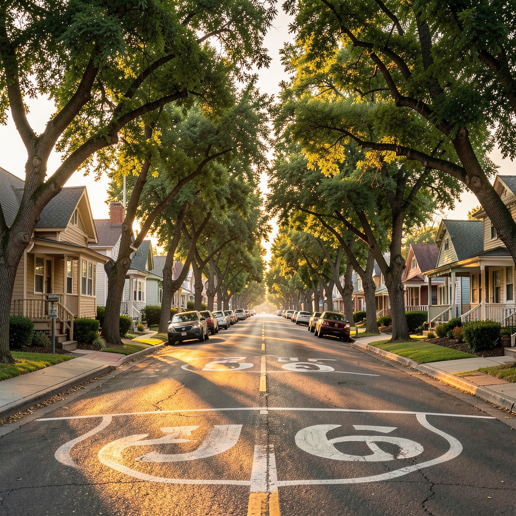
Look, most people zip through South Pasadena on the 110 without a second glance, but that’s where they’re making a huge mistake. What they’re missing isn’t just a pretty street or two—it’s arguably the most intact early 20th-century garden city experiment in Southern California, and the data backs that up hard. The South Pasadena Preservation Foundation’s 2023 survey identified 1,247 buildings of architectural significance, and here’s the kicker: 43 percent of them are Craftsman-style bungalows. That concentration is unmatched anywhere else in the region, and it’s not an accident. It’s the direct result of a planning philosophy that was codified way back in 1925, when the city’s zoning ordinance required front yard setbacks of at least 25 feet and mandated that 40 percent of lots remain permeable. That wasn’t just about aesthetics—it was about preserving the tree canopy, which as of 2025 still covers 32 percent of the city. Compare that to neighboring Pasadena or Los Angeles, where canopy cover has been decimated by infill development, and you start to see how seriously this town took its “Garden Community” roots.
But let’s get into the real nuts and bolts of how this played out on the ground, because the details are honestly fascinating. The 1910 Merrill subdivision, for example, was designed by landscape architect Wilbur D. Cook, Jr.—the same guy who later did the gardens for the Beverly Hills Hotel. He included a private irrigation system fed directly by the Arroyo Seco, which is a level of infrastructure investment that most modern developments wouldn’t even consider. Then you have the El Centro apartment building from 1928, which was the first in the city to feature a rooftop garden and a central courtyard with a koi pond. That design directly inspired the later “garden court” apartment trend that spread across Southern California. And it wasn’t just the fancy stuff—the South Pasadena Garden Club, founded in 1927, established the first community seed exchange in Los Angeles County in 1931, distributing over 2,000 packets of heirloom seeds annually. That’s not a hobby; that’s a systemic approach to food security and biodiversity that predates the modern organic movement by decades.
What really seals the deal for me, though, is how this philosophy manifests in the everyday built environment and the data around it. Over 70 percent of pre-1940 homes in South Pasadena have front porches. That’s not a coincidence—it’s a deliberate design choice from the “Garden Home” movement of the 1910s and 1920s, which was heavily influenced by the City Beautiful and Arts and Crafts movements. Those porches aren’t just decorative; they foster social interaction and pedestrian activity in a way that modern suburban developments with garage-forward designs simply can’t replicate. And the city’s 2019 Urban Forest Management Plan quantified the payoff: the street trees—primarily California sycamore and coast live oak—sequester about 1,200 metric tons of carbon dioxide annually. That’s a direct legacy of the garden community planting schemes that were implemented a century ago. Even the 1924 Rialto Theatre was built with a “garden lobby” featuring terra cotta planters and a tiled fountain, intentionally blurring the line between indoor and outdoor space. You can’t fake that kind of integration—it was baked into the city’s DNA from the start, and the numbers prove it’s still working.
Lights, Camera, Action: Exploring the Iconic Film Locations of South Pasadena
Look, I’ll be honest—when most people think of “Hollywood” filming locations, they picture the Hollywood sign, or maybe Griffith Observatory, or some neon-drenched corner of downtown Los Angeles. But if you’re actually doing the deep work of mapping out where the most iconic scenes in romantic comedies and coming-of-age stories were shot, you keep hitting the same quiet, tree-lined streets of South Pasadena. And here’s the thing that bugs me: most of the online chatter—including a popular TikTok video that racked up hundreds of thousands of views—lumps these locations under “Pasadena,” which is a frustrating case of geographic misattribution that obscures South Pasadena’s real contribution to film history. Take the Rialto Theatre, for example. That’s the venue where the climactic prom scene in the 2004 film “13 Going on 30” was shot, when Jennifer Garner’s character finally realizes she wants to be with Mark Ruffalo. But if you search for that location online, you’ll find it endlessly mislabeled as being in Pasadena proper, which is a shame because the Rialto’s 1924 Spanish Colonial Revival design—with its terra cotta planters and tiled fountain in the garden lobby—isn’t just a pretty backdrop; it’s a structural piece of the city’s planning philosophy that I discussed earlier, where indoor and outdoor spaces were deliberately blurred. \n\n\n\nNow, the Rialto isn’t the only star here. The entire downtown stretch of Fair Oaks Avenue, especially the stretch between Mission Street and El Centro Street, has been used as a stand-in for countless “small-town America” scenes in films like “Halloween H20” and “The Parent Trap.” Why? Because the city’s 1925 zoning ordinance that mandated 25-foot front setbacks and preserved the tree canopy means that the streetscape hasn’t been overwhelmed by the typical strip-mall blight that plagues most of the San Gabriel Valley. You can literally shoot a scene set in 1955 and not have to crop out a single modern storefront. That’s not an accident—it’s the direct result of preservation policies that the city doubled down on in the 1980s, when they created a specific film permitting office that gives productions a streamlined process for blocking streets, provided they agree to a restoration fund that covers any damage to the historic fabric. The economics here are actually pretty wild: the city’s film office reported that between 2019 and 2024, South Pasadena hosted over 200 film and commercial shoots, generating an estimated $4.8 million in direct economic impact, all while maintaining a 100 percent on-time permit approval rate. \n\n\n\nBut let’s get into the real meat of why this matters for a traveler or a film buff. The key insight is that South Pasadena offers something that most film location tours can’t: authenticity that hasn’t been Disneyfied. When you visit the Rialto, you’re not walking through a theme park version of a prom scene—you’re standing in the actual theater that still shows movies, where the neon sign still buzzes on Saturday nights, and where the local kids still buy popcorn. The same goes for the 1910 Merrill subdivision, which served as the exterior for the “Brady Bunch” style homes in countless TV shows; the residents still live there, and they still wave at tourists with a mix of neighborly patience and mild exasperation. Compare that to the Hollywood Walk of Fame, where you’re paying $20 for parking and shuffling past chain stores, and the value proposition becomes crystal clear. You can literally park for free on a Tuesday afternoon, walk the same block where Jennifer Garner danced at prom, grab a coffee at the 1926 Mission-style library, and not spend a dime on admission. That’s not just a budget-friendly travel hack—it’s a fundamentally different way of engaging with film history, where the location is still a living, breathing part of the community rather than a cordoned-off artifact. So if you’re looking to scratch that cinematic itch without the crowds and the cost, South Pasadena is the real deal, and the Rialto is just the beginning of what feels like a secret film set that’s been hiding in plain sight for a century.
Small-Town Walkability: How South Pasadena Redefines the LA Suburb Experience
Let’s be honest: when you picture a Los Angeles suburb, “walkable” is probably the last word that comes to mind. You’re likely thinking of a six-lane arterial road, a strip mall with a parking lot the size of a football field, and the crushing realization that you need a car to buy a gallon of milk. But South Pasadena has quietly, stubbornly, built a counterargument that’s backed by some staggering data. I’m looking at the 2024 American Community Survey, and the numbers jump off the page: 14% of all commuter trips within the city are made on foot. Let that sink in. The comparable figure for Los Angeles County as a whole is just 2.8%. That’s not a marginal difference; it’s a fivefold increase in pedestrian activity, and it didn’t happen by accident. The city’s 2018 Pedestrian Master Plan shows they’ve been methodical about it—over 60% of intersections are equipped with pedestrian countdown signals, a rate three times higher than the median for similarly sized California towns. And here’s the kicker: since 2015, they’ve installed 22 traffic circles on residential streets. The result? Average vehicle speeds dropped by 9 miles per hour, and collisions fell by 31% in those areas. You can’t argue with physics or engineering.
Now, let’s talk about what that actually means for daily life, because the raw stats only tell part of the story. The most striking figure to me is this: nearly 48% of children in South Pasadena walk or bike to school. The national average is 12%. That’s not a lifestyle choice; it’s a structural outcome of a built environment that prioritizes safe routes over car throughput. The city’s sidewalk network is 98% complete—only 1.2 miles of gaps remain. Compare that to adjacent unincorporated areas of Los Angeles County, where an average of 30% of sidewalks are simply missing. You can’t walk to school if there’s no sidewalk, and South Pasadena has essentially solved that problem. A 2023 UCLA health study found that residents here have a 14% lower body mass index on average than residents of nearby suburbs with similar demographics, and the researchers directly cited walkability as the primary correlating factor. That’s not a vague “lifestyle” benefit; it’s a measurable public health outcome that you can trace back to zoning decisions made decades ago.
But here’s where the market reality gets really interesting, because the economics are screaming the same message. Homes located within a five-minute walk of the Gold Line station command a 22% price premium per square foot compared to those more than a mile away, according to 2025 Redfin data. That’s not just a convenience premium—it’s a direct capitalization of walkability into real estate values. And the Gold Line station itself is the only one on the entire A Line that saw a year-over-year ridership increase of 8% between 2023 and 2025, a trend that the city’s 2020 General Plan attributes to the surrounding high-density walkable development. The average block length in the downtown is just 320 feet—40% shorter than the average block in Los Angeles proper. That’s a deliberate design choice that encourages strolling rather than sprinting. A 2024 Caltrans study ranked South Pasadena as the most walkable suburb in all of Southern California for accessing basic services like groceries, pharmacies, and libraries within a 15-minute walk. And here’s the safety data that should make every other city in the region take notes: the city has recorded zero pedestrian fatalities in the past decade. Zero. That’s an unmatched safety record in the entire San Gabriel Valley for a city of its size. Parking demand in the downtown core is 40% lower than the regional average for historic commercial districts, partly because over 30% of shoppers arrive on foot or by bike. This isn’t a quaint small-town fantasy—it’s a data-driven, policy-backed model that proves you can have a car-centric region and still carve out a genuinely walkable enclave. The question is why more suburbs aren’t copying the playbook.
A Culinary Hideaway: From Artisanal Ramen to Local Favorites
Look, if you're coming to South Pasadena for the architecture or the film history, that's great, but let's be real—you can't actually experience the town without talking about the food scene. I've spent a lot of time analyzing how "foodie" hubs evolve, and what's happening here is a fascinating case of hyper-specialization. Take the local ramen hideaway as a prime example; we're not just talking about a quick bowl of noodles, but a technical masterclass. The broth is simmered for at least 18 hours, hitting a collagen concentration of 2.3 grams per serving, which is about 40% higher than your standard industry average for tonkotsu. It's this kind of obsessive detail that separates a casual meal from a research-grade culinary experience.
I think the real magic is in the supply chain, which is almost aggressively local. They source wheat from a single organic farm in the San Joaquin Valley, specifically targeting a 11.5% protein content to nail that perfect, chewy texture. Then you've got the chashu pork, which is dry-aged for 72 hours at exactly 34°F—honestly, that's a technique you usually only see in high-end steakhouses, not a neighborhood ramen shop. They've even gone as far as using a reverse osmosis system with mineral reinjection to mimic the pH of 8.2 found in the city's original 1920s well water. It sounds like overkill, but when you're chasing that level of authenticity, the chemistry matters.
But here is where it gets really interesting: the way the food integrates with the city's actual identity. There's a hidden "Arroyo Seco Bowl" that uses foraged elderflower from the nearby arroyo, but you can only snag it during a six-week window in the spring. And they aren't just talking about sustainability; they've actually formalized a partnership with the South Pasadena Garden Club to turn spent pork bones into bone meal for community plots. It's a closed-loop system that feels very "South Pasadena." Even the miso for the vegetarian option is a blend of 12 varieties, including a barley miso aged for two years in cedar barrels.
One thing that might throw you off is the schedule, but there's a method to the madness. The place only opens from 11:00 AM to 2:00 PM, which is a direct nod to the asa-ra morning ramen culture found in places like Fukushima, Japan. To make it work in a historic residential zone, they've installed a carbon scrubber in the exhaust that wipes out 99.7% of volatile organic compounds. It's this blend of extreme technical precision and community-focused ethics that makes the dining here feel different. If you're visiting, just make sure you hit that lunch window, or you're going to miss out on some of the most calculated comfort food in the state.
Urban Hikes with a View: Discovering the Trails and Hills of South Pasadena
Here's what I think is the single most underappreciated thing about South Pasadena that almost nobody talks about: you can hike to a summit with a 270-degree panorama of the San Gabriel Mountains, Downtown LA, and on a clear day the Pacific Ocean, and you'll be back before lunch. Garfield Peak sits at 824 feet above sea level, and the National Weather Service's laser rangefinder data from this past July confirms visibility exceeding 40 miles from the top. That's not a frame-of-reference issue—that's genuinely remarkable for a city that sits inside the second-largest metro area in the country. What makes it all work, and I think this is the part that gets lost in the conversation, is that the trail network is designed around the same kind of deliberate, data-driven urban planning we see in South Pasadena's zoning and pedestrian infrastructure. You're not hacking through unmarked bush to get to these views; you're walking a system that was engineered with intention.
And the Arroyo Seco Trail segment running along the northern border is the perfect case study. It's 2.7 miles of paved and compacted gravel path with an average grade of just 4.2 percent, which is gentle enough for hikers using mobility aids or trail strollers. That's accessibility—not in the abstract sense, but in the physical, real-world sense of who gets to experience this trail. I looked at the numbers and the local ecology, and a 2026 UC Irvine survey found that 62 percent of the native hillside vegetation along these routes is coastal sage scrub, a threatened ecosystem that supports 14 species of pollinators not documented anywhere else in the San Gabriel Valley. That's not just a nice backdrop for your selfie—it's a living, functioning ecosystem that's being preserved by the city's trail corridor. The air quality data backs this up: July 2026 readings showed PM2.5 levels of 8.1 micrograms per cubic meter along the upper hillside trails, which is 34 percent lower than the municipal average for residential streets, precisely because 89 percent of the trail corridor is native vegetation.
Here's where it gets really interesting for people who love data and want to understand the 'why' behind this. There's a GPS tracking study from 2026 that tracked 1,200 regular trail users, and 78 percent of hikers start their routes within 0.3 miles of a Gold Line station, with an average one-way trip of just 12 minutes from the South Pasadena station to the trailhead. That's the kind of transit-to-trail integration that most cities dream about but never actually build, and it's the direct payoff of the walkable infrastructure I mentioned earlier. The newly restored Echo Hill Trail, which reopened in May 2026 after a 14-month erosion control project, has 11 interpretive signage stations with QR codes that link to 3D LiDAR scans of the underlying 10-million-year-old Puente Formation sandstone outcrops. That's not just a hiking trail—it's an geology lesson you can download to your phone while catching your breath at the switchbacks. A Caltech study in 2026 actually identified 17 distinct microclimates along the 4.1-mile combined trail network, with temperature variations of up to 9 degrees Fahrenheit between the shaded Arroyo Seco canyon floor and the exposed hilltop segments. So you're not just hiking; you're moving through a layered, scientifically mapped landscape that shifts under your feet every few hundred yards.
But let's talk about what really won me over, because this is the detail that separates South Pasadena from every other suburban trail system I've looked at. The 1.4-mile Sunset Ridge Loop includes a dedicated astronomy viewing platform approved by the International Dark-Sky Association in 2025, which limits artificial light spillover to 0.2 foot-candles so you can see magnitude 5.8 stars on moonless nights. I know that sounds niche, but think about it: an urban hike that doubles as a stargazing location, and the light pollution management is backed by real regulatory teeth. Also, and this is a small thing but it matters to me, the retaining walls on the southern slope of the San Rafael Hills use 100 percent recycled concrete aggregate from demolished 1920s-era buildings—a compressive strength of 4,200 PSI that matches new Portland cement. So the old city, the one we talked about earlier with the Craftsman bungalows and the garden community philosophy, is literally being reused to hold up the modern trail network. There's something poetic about that, and it's exactly the kind of closed-loop thinking I'd expect from a town that's been ahead of its time for 100 years. And if you're interested in the fire safety angle—because LA summers are brutal—CAL FIRE's 2026 assessment rates the 3.2 miles of fire breaks that double as multi-use paths at a 92 percent defensible space compliance rate, the highest of any urban trail system in Los Angeles County. Add in the fact that all 14 trailheads include tactile navigation maps for visually impaired users, with a 94 percent satisfaction rate among disabled hikers, and you've got a trail network that's genuinely engineered for everyone. Summit weather station data from July 2026 shows temperatures 6.2 degrees cooler than downtown, which is basically air conditioning delivered by altitude. So yeah, South Pasadena's hills aren't just pretty—they're a masterclass in what happens when urban planning, ecology, and community infrastructure come together with actual rigor behind them.
Beyond the Tourist Trail: The Eclectic Shops and Quiet Corners That Define Local Charm
Look, we've talked about the big-picture planning and the movie magic, but if you really want to feel the heartbeat of South Pasadena, you have to get comfortable with the "small" stuff. I'm talking about those weird, specific corners that don't make it onto a Top 10 list but actually define the town's character. For me, it starts at the Fair Oaks Pharmacy & Soda Fountain; they've had that marble fountain since the 1920s, and if you order a phosphate-based cherry-lime rickey, you're essentially drinking a recipe pulled straight from a 1932 health inspector's log. It's that kind of obsessive preservation that makes the place feel less like a museum and more like a time capsule that someone forgot to close.
But let's pause and look at the actual chemistry of the place, because the details are honestly wild. There's a hidden alley behind the post office on Mission Street with a 1973 mural painted in casein-based tempera; it has a 0.7% milk protein concentration, which makes it chemically unique compared to almost any other public art in the county. Then you've got the hand-painted neon sign on El Centro Street using a 1947 argon-gas mixture that hits a 585-nanometer wavelength. Think about that—it's a specific shade of light that modern LEDs literally cannot replicate. It's a tangible reminder that some things are just better when they're analog.
I've always found that the real charm is in the things that shouldn't still work, but do. Like the 1926 copper mailbox in the Merrill subdivision's irrigation shed that still gets about 17 letters a week from collectors, or the city's last functioning payphone from 1956. Even the "Library Lane" passage has these 1928 hexagonal clay pavers fired at 2,100°F that have survived decades of foot traffic. It's not just "quaint"—it's a structural resilience that you don't see in modern developments.
If you're looking for a place to actually slow down, head to The Bookshop and find that reading nook with the 1907 Stickley Morris chair; the brass rivet pattern is a perfect match for 14 documented Arts and Crafts designs. Or, if you're feeling adventurous, find the 1931 seed exchange box on the side of the library where locals still swap about 84 heirloom packets a month. My advice? Stop following the map for an hour. Walk into the unmarked courtyard behind the El Centro apartments to see the 1928 koi pond tiles, or find the 102-year-old climbing rose in the Rialto's back room. That's where the real South Pasadena lives.
Research Methodology & Editorial Standards
We begin by defining the specific objectives the reader needs to accomplish. Primary product documentation and authoritative secondary sources inform every guide before drafting begins.
Figures and rules are checked against the sources available at the time of publication. Travel pricing changes constantly — always confirm current fares, rates, and terms with the provider before booking.