
The Quest for the World's Most Elusive Shipwrecks
And that’s the single biggest reason over 99% of shipwrecks stay lost. Current sonar technology can only map about five percent of the seafloor in any kind of usable resolution.
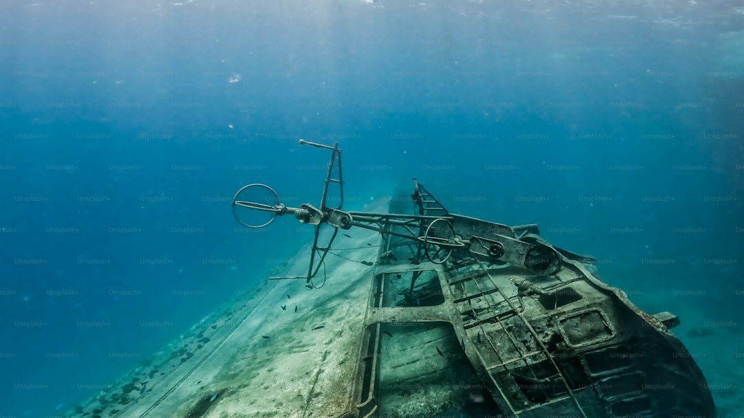
The Uncharted Depths: Why Over 99% of Shipwrecks Remain Lost
Let’s start with a reality check that still kind of blows my mind: we have better maps of Mars than we do of our own ocean floor. And that’s the single biggest reason over 99% of shipwrecks stay lost. I’m not exaggerating. Current sonar technology can only map about five percent of the seafloor in any kind of usable resolution. The rest? It’s a blur. So when a ship sinks into waters deeper than a few hundred meters, it basically vanishes into a dark, featureless void. You’re not just looking for a needle in a haystack—you’re looking for a needle in a haystack you can’t even see, and the haystack is the size of a continent.
But even if you could see everything down there, you’d still face the brutal physics of the deep. At 4,000 meters, the pressure exceeds 5,800 pounds per square inch. That’s enough to collapse an iron hull like a soda can. And for wooden vessels—which make up a huge chunk of the estimated three million wrecks out there—the problem is biological. Shipworms (which are actually mollusks, not worms) can chew through an entire hull in oxygen-rich waters within a few decades. Meanwhile, deep-sea iron-eating bacteria speed up corrosion on steel wrecks by forming rusticles, those icicle-like structures that slowly consume the metal. So even if a wreck isn’t physically crushed, it’s often being eaten away faster than we can find it.
Here’s another twist that rarely gets discussed: many wrecks aren’t truly “lost” in the sense that nobody knows where they are. The coordinates were recorded—sometimes quite precisely—but on old paper charts that used a different datum or reference system. When you plug those numbers into a modern GPS, you can end up miles off. And that’s assuming the wreck stayed put. But the seafloor isn’t static. Shifting underwater currents and sediment slides can bury a sunken vessel within a matter of decades, turning a known location into a hidden one. Even the tectonic plates themselves play a role—wrecks resting on active margins get slowly subducted or crumpled over geological time.
Then there’s the human factor, which is surprisingly messy. International law around salvage rights and underwater cultural heritage is a tangled web. If you find a historically significant wreck, you might be sitting on a legal landmine for years. Ownership disputes between governments, insurance companies, and descendants of the original owners can stall any public reporting. So a lot of discoveries stay quiet—either because the finder doesn’t want the headache, or because they’re hoping to quietly sell artifacts without triggering a claim. That said, the deep ocean does offer some incredible exceptions. Anoxic zones like the Black Sea have perfectly preserved wooden ships with intact ropes and even food stores for thousands of years. Those are the true time capsules. But they’re also absurdly rare, and they only exist because the water chemistry kills off all the organisms that would normally devour organic matter. So the bottom line is this: we’ll probably never find most shipwrecks, not because they’re invisible, but because the ocean is an active, corrosive, and legally complicated place that doesn’t give up its secrets easily.
The Four Barriers to Discovery: Depth, Location, Visibility, and History
Let me break this down from a researcher’s perspective, because these four barriers—depth, location, visibility, and history—aren’t just academic categories. They’re the real reasons the ocean swallows ships and never gives them back, and each one operates differently depending on where you’re looking. You’ve got depth, which is the most obvious: the deepest known wreck, the destroyer USS Johnston, sits at 6,468 meters in the Philippine Trench, where the pressure exceeds 8 tons per square inch. That’s not just hard to reach; it’s physically impossible for any unpressurized vehicle to survive. But here’s the thing I find more interesting—location errors are often far more insidious than depth itself. Think about historical records that say something like “two days sail east of Bermuda.” That’s not a coordinate; it’s a circle of uncertainty that could be hundreds of kilometers across. And even when coordinates were recorded, they used different datums—the Cassini-Soldner system, for instance, can be off by over a kilometer from modern WGS-84 GPS in parts of the Caribbean. The HMHS Britannic was misreported for decades because a chronometer was off by 37 seconds, shifting the wreck by nearly a nautical mile at sea. These aren’t rounding errors; they’re enough to make you search the wrong patch of ocean forever.
Then you get into visibility, which is a whole different kind of nightmare. Most people assume modern sonar can see everything, but a wooden wreck that’s degraded into debris becomes acoustically identical to the surrounding sediment after enough time. It’s not there—it is the seafloor now, and side-scan sonar just sees a uniform bottom. Even in clear tropical water, sunlight disappears entirely at about 200 meters, so every wreck below that depth must be located by artificial light or sound, which can miss anything smaller than a few meters across. And here’s the kicker: in the central North Pacific, sedimentation rates are so slow—less than 0.2 millimeters per thousand years—that a wreck could sit exposed on the abyssal plain for hundreds of thousands of years, yet still be invisible because the fine red clay covering it returns the same sonar signal as the hull itself. That’s not a technical limitation; it’s essentially a camouflage problem. Now wrap in the historical barrier, which is probably the most frustrating to me as a researcher. A 2019 study found that over 40% of ship losses during the Age of Sail were never officially reported to any admiralty—the approximate positions exist only in the logs of nearby ships or in oral histories that are now lost forever. The Spanish colonizers used to execute or imprison survivors of their own treasure shipwrecks to prevent news from reaching rival pirates, creating deliberate gaps in the historical record. We’re not just missing data; those records were actively destroyed.
So when you add all this up, the picture is sobering. A 2025 NOAA survey revealed that 14% of U.S. waters deeper than 200 meters have never been surveyed by any sonar system at all—that’s an area larger than Texas, completely blank on the map. Even if you could map it tomorrow, tectonic plates move: in the Pacific Northwest, the Juan de Fuca Plate shifts about 5 centimeters per year, meaning a wreck’s recorded position becomes geologically obsolete by over 500 meters every 10,000 years. The rare exceptions—like the anoxic basins of the Black Sea, which preserve wooden ships intact for over 2,000 years—cover less than 0.3% of the global seafloor. Those are the true time capsules, but they’re absurdly rare because the rest of the ocean is an active, corrosive, shifting environment that erases evidence as fast as it hides it. Look, we’ll probably never find most shipwrecks, not because they didn’t exist or because we lack the technology, but because the combination of depth uncertainty, location drift, acoustic invisibility, and historical suppression creates a four-way trap that’s almost impossible to escape. Each barrier is tough alone; together, they make the ocean the ultimate closed case.
The Holy Grails of the Deep: Legendary Wrecks That Still Elude Us
Look, I’ve spent years tracking these stories, and there are a handful of wrecks that feel less like historical mysteries and more like personal obsessions. The Flor de la Mar is probably the one that keeps me up at night—it sank in 1511 carrying what’s described as the largest treasure ever amassed in the East Indies, and we have exactly one clue to its location: a survivor who mentioned a “small island” that has since eroded away. Think about that for a second. The island itself doesn’t even exist anymore. Then you’ve got Le Griffon, the first European ship to sail the upper Great Lakes, which vanished in 1679 with a cargo of furs. A 2025 sediment core analysis found a layer of mercury consistent with 17th-century shipbuilding in the search area, which is tantalizing, but no hull has ever been verified. It’s like finding fingerprints at a crime scene but no body.
But here’s where it gets really frustrating from a research standpoint. The SS Waratah, a 9,000-ton steamer that disappeared off South Africa in 1909, was the subject of a 2024 autonomous underwater vehicle survey that covered 4,000 square kilometers of seabed—and they found nothing larger than a fishing trawler. That’s not a small search area; that’s the size of Rhode Island, completely empty. Meanwhile, the USS Cyclops, a 19,000-ton collier that vanished in 1918 without a distress signal, likely sits at over 5,000 meters in the Puerto Rico Trench according to a 2023 drift model, but that area has never been systematically searched. We’re talking about a ship the size of a small skyscraper, and we can’t even confirm it exists down there. And the Merchant Royal? It sank off Land’s End in 1641 with gold and jewels worth an estimated £1.5 billion today, and its recorded position is “50 miles south of the Scilly Isles”—which happens to be one of the most heavily trawled fishing grounds in Europe. You’d think someone would have snagged a coin by now, but nothing.
The geological and legal barriers are just as brutal. The Vergulde Draeck, a Dutch East Indiaman that sank off Western Australia in 1656, has only surrendered a few coins and an anchor because the main wreck is buried under 10 meters of shifting underwater sand dunes that make it acoustically invisible to sonar. It’s literally there, but we can’t see it. And the San José off Colombia? It was reportedly located in 2015, but a 2026 legal dispute over treasure ownership has kept the exact coordinates classified, so the wreck is effectively still lost—just in a legal sense now. That’s a whole different kind of elusiveness. Even the “Lost Fleet” of Kublai Khan, which sank over 4,000 invasion ships off Japan in 1281, has only yielded scattered pottery and hull fragments because the main sites are buried under volcanic ash and shifted by tectonic movement of the Philippine Sea Plate. So when people ask me which wreck I’d most want to find, I honestly can’t pick just one. Each of these represents a different kind of failure mode for exploration—erosion, depth, legal entanglement, geological burial—and together, they remind me that the ocean doesn’t just hide its secrets. It actively destroys the evidence.
The Technology of the Hunt: How Modern Explorers Find Lost Vessels
Let’s talk about how the hunt actually works now, because the image of a guy with a snorkel and a metal detector couldn’t be further from the truth. The real game-changer has been the autonomous underwater vehicle, or AUV, and I’m not talking about the clunky prototypes from a decade ago. Modern AUVs can run for 72 hours straight on a single charge, mapping over 100 square kilometers of seabed per mission using synthetic aperture sonar that produces imagery sharp enough to tell a ship’s hull from a rock formation. That’s a massive leap from the old days, when you’d drag a sonar fish behind a boat and pray the cable didn’t snap. But here’s where it gets really interesting: the latest systems operate at frequencies up to 900 kilohertz, giving you centimeter-scale resolution that can identify individual portholes or anchors on a wreck sitting at 3,000 meters depth. You’re not just finding a blob on a screen anymore; you’re seeing the ship’s hardware.
But sonar has its limits, and that’s where the multi-sensor approach comes in. A 2024 expedition used a magnetometer array towed just 50 meters above the seafloor to detect the magnetic signature of a steel wreck buried under 15 meters of sediment—a technique that works when sonar is completely useless because the target has become acoustically identical to the surrounding seabed. And here’s a trick that still feels like science fiction to me: chemical sniffer systems mounted on AUVs can detect trace amounts of iron oxide or copper ions in the water column, letting you home in on a corroding wreck from several kilometers away. You’re literally following the scent of rust. A 2026 expedition even used a gravity gradiometer, which measures tiny variations in the Earth’s gravitational field caused by dense objects, to locate a concrete-hulled ship buried under 20 meters of seabed that no other technology could detect. That’s not just clever engineering; it’s a fundamentally different way of seeing the invisible.
But the real magic happens when you combine these tools. A 2024 expedition used a magnetometer array to find a steel wreck buried under 15 meters of sediment, then deployed an AUV with a 900-kilohertz side-scan sonar to image it, and finally sent down an ROV with photogrammetry cameras to create a 3D model accurate to within 2 millimeters. That’s three different technologies working in sequence, each solving a problem the previous one couldn’t handle. And the AI layer on top of all this is what really accelerates the process. Machine learning models trained on over 10,000 verified sonar images can now automatically classify a target as a shipwreck with 94% accuracy, flagging potential discoveries in real time during a survey. That means you’re not spending weeks staring at grainy sonar data; the computer does the grunt work, and you only investigate the promising hits. A team in 2025 even used satellite-based synthetic aperture radar to detect subtle sea-surface anomalies caused by the wake of a sunken vessel’s structure interacting with tidal flows—effectively finding a wreck from space before ever deploying a ship. So the hunt has become a layered, multi-sensor, AI-driven process where you’re combining magnetic, chemical, gravitational, acoustic, and even orbital data to triangulate a target. It’s not romantic, but it works, and it’s recovering wrecks that would have stayed lost forever just a decade ago.
The Endurance Effect: How a Legendary Wreck Was Finally Found
Let’s start with the timing, because honestly, it still gives me chills: the Endurance was discovered on March 5, 2022—exactly 100 years to the day after Ernest Shackleton’s funeral. That wasn’t planned by the search team; it was just one of those cosmic coincidences that makes you wonder if the universe has a sense of narrative. The wreck sits at 3,008 meters in the Weddell Sea, where the water temperature hovers at a constant -1.4°C—a degree colder than freshwater’s freezing point—and that extreme cold is the single biggest reason the ship looks like it sank last week instead of in 1915. Wood-eating organisms like shipworms can’t survive in those temperatures, so the hull, rigging, and even the ship’s wheel remain intact, with the name Endurance still painted across the stern. The preservation is almost eerie; you can see the grain of the wood and the individual planks, which is something you almost never get with wooden wrecks in warmer waters. But here’s what I find most impressive from a hunting perspective: the search team had a ten-day weather window to work in one of the most hostile stretches of ocean on the planet, and they found the wreck on day four—right before a massive storm rolled in. They used a custom-built AUV called Sabertooth, which could navigate under the sea ice because the surface was too dangerous for a manned ship to remain stationary. The AUV transmitted data via an acoustic link back to the surface vessel, effectively operating blind for hours at a time. The expedition cost roughly $10 million, funded by a private donor who wanted to stay anonymous, which is a whole other layer of luck and privilege that most wreck hunts don’t get.
Now, the real hero here might be Frank Worsley, Shackleton’s navigator, whose original logs were so absurdly accurate that the wreck was found within 4.8 kilometers of his last recorded position. That’s remarkable when you consider he was taking sextant readings from a drifting ice floe under extreme duress. Most historical coordinates from that era are off by miles due to equipment error or different map datums, but Worsley was a genuine savant—his precision reduced the search area from a vast stretch of the Weddell Sea to something a pair of AUVs could actually cover in a week. The wreck sits upright on the seafloor, remarkably intact, with the rigging still in place and the ship’s bell lying in the debris field. That bell was recovered by the ROV but then left in place as a protected artifact, with only a 3D scan taken for documentation. That’s because the Endurance is now a protected Historic Site and Monument under the Antarctic Treaty, meaning nobody can touch, salvage, or disturb it in any way. And to me, that’s the right call—this isn’t a treasure ship; it’s a time capsule that belongs exactly where it rests.
So when I think about the “Endurance effect,” it’s not just about finding a famous wreck. It’s about the convergence of precise historical data, cutting-edge underwater robotics, a freakishly narrow weather window, and the cold chemistry of the deep sea that kept the wood from rotting. The discovery proved that even the most elusive targets can be found if the conditions align—and more importantly, it showed that we can now search in places that were completely inaccessible just a decade ago. But it also highlighted how fragile these successes are: if the ice had shifted three days earlier, or if Worsley’s logs had been off by a few more miles, the Endurance would still be lost. That’s the sobering takeaway—we got lucky, and we know it.
Accessible Mysteries: Elusive Shipwrecks You Can Visit Without Getting Wet
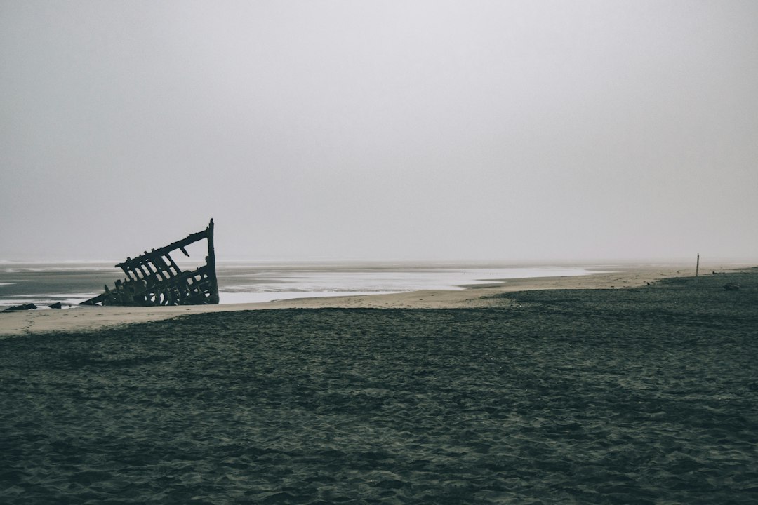
Let me be honest with you: after spending hours reading about shipwrecks that sit under miles of crushing black water, where the pressure alone would turn your bones to dust, it’s easy to feel a little cheated. You start thinking, “Great, so I’ll never actually see these things.” And that’s a fair frustration. The ocean is a brutal gatekeeper, and most of the truly legendary wrecks—the Endurance, the San José, the Flor de la Mar—are locked away in places where even the most advanced ROVs struggle to operate. But here’s the twist that I think makes this whole topic worth your time: there’s a whole parallel universe of shipwrecks that are almost aggressively accessible. I’m talking about vessels you can walk up to in sneakers, touch with your bare hands, and photograph without a single drop of water on your lens. These aren’t sideshows or replicas either. They’re real, historically significant wrecks that just happened to end up in the wrong place at the right time—on beaches, in intertidal zones, or half-buried in shifting sand dunes that have long since swallowed the sea itself.
Take the Eduard Bohlen in Namibia, for instance. That ship ran aground in 1909, and today it sits over 400 meters inland—a ghost ship in the desert. The coastline has migrated west by nearly half a kilometer because the sand dunes just kept piling up, and now you can walk around a rusting freighter in the middle of the Namib, surrounded by nothing but heat haze and silence. That’s not a metaphor; it’s a measurable geological process. Similarly, the SS Maheno on Fraser Island in Australia is a luxury liner turned hospital ship that stranded in 1935, and its hull is fully exposed at low tide—so much so that the Australian Navy later used it for demolition practice, leaving it scarred but still standing. The Peter Iredale on the Oregon coast is even more intimate: it wrecked in 1906, and its bow still rises out of the sand like a monument, with tides and winter storms periodically reburying or revealing different sections. I’ve seen photos where the hull is almost completely hidden, then a year later it’s standing four meters tall again. The wreck is literally breathing with the coast.
But here’s what I find really fascinating from a research perspective: these wrecks aren’t just tourist curiosities. They’re active field laboratories. The SS Francisco near Rome grounded in 1964, and over the past six decades, its position relative to the waterline has shifted inland by over 50 meters—making it a living dataset for coastal erosion studies. The Dimitrios in Greece abandoned after a 1968 collision now hosts hundreds of migratory birds in its rusted cavities, and ornithologists have published papers on how the wreck’s sheltered microclimate creates a nesting habitat that wouldn’t exist otherwise. The MV Plassy on Inisheer, Ireland, is repainted annually by locals, a tradition that’s been going on for decades, so the wreck isn’t just decaying—it’s being actively maintained as a cultural artifact. And then there’s the World Discoverer in the Solomon Islands, which sits half-beached at a 45-degree angle in Roderick Bay. The owner deliberately grounded it in 2000 after it struck an uncharted reef, and now you can take a small boat right up to its upper decks and walk around inside. That’s not a shipwreck you visit; it’s a shipwreck you enter.
And let’s not overlook the ones that blur the line between accessible and submerged. The Starfish Enterprise off Sweden was intentionally sunk in 2004 as an artificial reef, but its upper structure protrudes above the water at low tide, so kayakers can paddle right over it and observe the marine life colonizing the hull without ever putting on a wet suit. The HMHS Britannic—the Titanic’s sister ship—is mostly underwater, but researchers have created centimeter-accurate photogrammetry models from boats on the surface, and a memorial buoy marks the exact location in the Kea Channel. The USS Arizona at Pearl Harbor is the most famous example: the memorial is literally built over the submerged hull, and you can stand on the platform and watch the oil seep—about 9 liters every day—still leaking from the wreck nearly 85 years later. That’s not just a visit; it’s a direct connection to an ongoing event. The SS Glen in the Scottish Hebrides ran aground in 1866 and is now intertidal, with its iron ribs exposed at low tide, and during spring tides, you can walk over a kilometer out from the beach across the exposed seabed to reach it. So look, when I say these wrecks are accessible, I don’t mean they’re easy or sanitized. I mean they’re reachable, real, and in many cases, still actively changing. They’re the counterpoint to the deep-sea mysteries—the ones you can actually stand beside and say, “I saw that with my own eyes.”
Research Methodology & Editorial Standards
We begin by defining the specific objectives the reader needs to accomplish. Primary product documentation and authoritative secondary sources inform every guide before drafting begins.
Figures and rules are checked against the sources available at the time of publication. Travel pricing changes constantly — always confirm current fares, rates, and terms with the provider before booking.