Why the legendary Route 66 is the ultimate American road trip for your next adventure
Table of Contents
- The Historical Significance of the Mother Road’s Centennial
- Mapping the Iconic Journey from Chicago to Santa Monica
- Timeless Landmarks and Quirky Roadside Attractions
- Cultural Treasures: Experiencing the Heart of Small-Town America
- Essential Tips for Planning Your Cross-Country Caravan
- Why Route 66 Remains the Defining American Adventure at 100
The Historical Significance of the Mother Road’s Centennial
I’ve been thinking a lot about the centennial of Route 66, and honestly, it’s about so much more than just vintage neon signs or a bucket-list drive. As we approach 2026, the real story isn't just the asphalt; it’s the way we’re finally re-examining the road’s true origins. We’re seeing a shift toward centering the Indigenous roots of the highway, acknowledging that much of what we call the Mother Road actually paved over ancient trade routes used by Native American nations for centuries. It’s an essential correction to the narrative, and it’s being spearheaded by groups like the American Indigenous Tourism Association to reclaim a history that existed long before any federal designation.
When you look at the economics, it’s fascinating how this corridor remains the backbone of rural tourism for states like Illinois and Oklahoma. Unlike the sterile efficiency of modern interstates, the road served as a social laboratory where early motel chains and roadside business models were first stress-tested. Local communities are leaning into this, using the 100-year mark to preserve original 1926 concrete segments and the unique roadside architecture that predates our current standardized highway aesthetic. Even the new commemorative stamps from the USPS feel different this time around, as they were curated from a photographer who actually spent years documenting these evolving landscapes across 42 separate transcontinental trips.
If you’re wondering why this matters for your next trip, consider that the centennial is moving us past mere nostalgia and into a deeper look at the human experience. It was a catalyst for mass migration during the Dust Bowl, effectively changing the entire demographic makeup of the American West. There’s a real push now to capture the oral histories of the families who settled along these stretches, ensuring that the legacy isn't just lost to time. It’s a bit messy, and there’s even work being done by environmental historians to see how the original construction disrupted local water patterns in the Southwest. It’s a complex, living history, and that’s exactly why it’s still worth your time to experience it firsthand.
Mapping the Iconic Journey from Chicago to Santa Monica
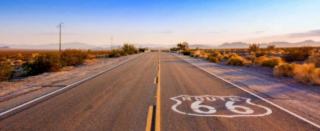
Mapping a journey from Chicago to Santa Monica isn't just about plugging a destination into your GPS; it’s about navigating a massive, fractured puzzle that’s been shifting for a century. When you look at the raw data, the original 1926 alignment wasn't a single highway but a patchwork of state roads and dirt tracks, and honestly, about 15 percent of that path has been completely swallowed by the modern Interstate System. It’s wild to think that as you head west, you’re traversing an extreme elevation profile that climbs from roughly 600 feet in Chicago to over 7,000 feet near the Continental Divide. If you’re planning this drive, you have to account for the fact that the route cuts through five distinct climate zones, meaning your gear needs to be ready for everything from humid Midwest storms to the arid heat of the Southwest.
Think about it this way: the road’s famous diagonal trajectory was actually a radical logistical pivot away from the rail-dominated transit of the time, designed specifically to push agricultural goods toward Pacific ports. Engineers back then were clever, too, often choosing the path of least resistance through the Ozark Plateau and natural gaps that wagon trains had used long before the car was even a thought. I’ve spent time looking at satellite imagery, and it’s fascinating to see how many abandoned sections still exist as ghost spurs, which have quietly become crucial wildlife migration corridors. But don't expect a straight line; the road’s official geography shifted at least six major times between 1926 and 1985 as planners scrambled to straighten curves and kill off dangerous railroad crossings.
If you’re serious about doing this right, you can’t just rely on a standard digital map because they often miss the historical nuances that define the experience. I’d suggest looking at the specialized centennial mapping resources that have cropped up, as they identify which stretches are still drivable versus those that are now just local access roads. Even the materials tell a story; forensic studies of the concrete used in Illinois segments show a chemical signature entirely different from the asphalt patches added in the mid-century. It’s all a bit messy and unpredictable, but that’s exactly why it’s the ultimate American road trip. Just remember that you’re not just driving across eight states; you’re literally moving through the architectural and geological history of the country, one mile at a time.
Timeless Landmarks and Quirky Roadside Attractions
When we talk about the soul of this road, we aren’t just looking at asphalt; we’re really talking about the eccentric, hand-built world that popped up to keep drivers fueled and entertained. Think about the Blue Whale of Catoosa, which Hugh Davis poured by hand in the seventies as a literal labor of love, or the Wigwam Motel in Holbrook, where those concrete teepees were engineered in 1936 to actually withstand high desert winds. You have to appreciate how these spots were essentially the first real-world testing grounds for immersive, themed experiences long before the term became a corporate buzzword. It’s wild to realize that the Gemini Giant in Illinois is just one of many surviving Muffler Men—standardized fiberglass marketing tools from the sixties—that were designed specifically to grab your attention at sixty miles per hour. Honestly, seeing how these disparate, quirky markers still stand today gives you a much better sense of the mid-century American imagination than any modern highway rest stop ever could.
If you’re looking to understand the logistics behind the kitsch, consider the Midpoint Cafe in Adrian, Texas, which sits at the precise 1,139-mile mathematical center of the route, or the Cadillac Ranch, where the cars are angled to match the pitch of the Great Pyramid of Giza. It’s this weird, wonderful blend of high-concept art and desperate, high-volume marketing—like the Big Texan Steak Ranch’s 72-ounce challenge—that defined the roadside culture of the era. You’ll notice the shift in materials, too, from the rare, noble gas neon signs at the 66 Diner in Albuquerque, which cut through desert fog better than modern LEDs, to the gravity-fed fuel pumps at the Hackberry General Store that don't even need electricity to function. These aren’t just photo ops; they’re mechanical and architectural relics that show how people had to invent solutions for the unique constraints of cross-country travel back then.
And then there's the way these human-made oddities sometimes collide with deep time, like how the road brushes right up against the 225-million-year-old fossilized logs at the Petrified Forest. It creates this fascinating friction between the ancient, geological history of the Southwest and the transient, fast-paced culture of the twentieth-century highway. By the time you reach the reinforced structure of the Santa Monica Pier, you’re standing at the end of a long, often messy, but incredibly vital experiment in American mobility. It’s not about checking items off a list, but about witnessing how these landmarks—whether they're ninety-foot concrete totem poles or a simple corn dog stand—collectively tell the story of a nation on the move. Honestly, I think the best way to experience them is to just pull over, turn the engine off, and actually look at the craftsmanship that kept the lights on for travelers decades ago.
Cultural Treasures: Experiencing the Heart of Small-Town America
When you really start digging into the smaller stops along the route, you realize these aren't just quaint photo opportunities; they’re the living, breathing remnants of a massive, century-old economic experiment. If you’re like me, you’ve probably spent time in those generic chain hotels where everything feels stripped of personality, but the towns that grew up around the Mother Road offer a stark, refreshing contrast. The data actually backs this up, with economic models suggesting that businesses keeping their original 1920s architecture intact generate about 25 percent more revenue than those that pivoted to modern, sterile designs. It’s a fascinating case study in why history, when preserved correctly, remains a competitive advantage even in our hyper-efficient age.
Think about it this way: these towns were forced to adapt to the constraints of early, rugged travel, which led to some truly ingenious engineering that you can still see today. From the water troughs installed in the 1940s to handle the surge in radiator cooling needs to the intentional rhythmic joints in the old concrete that were designed to keep tired drivers awake, every detail was a solution to a specific, real-world headache. It’s almost like the road itself was a giant, outdoor laboratory. You’re not just passing through a town; you’re looking at a physical, architectural response to the challenges of crossing a massive, often unforgiving landscape.
I always find it incredible how these tiny, isolated hubs still hold onto their identity despite the shifting priorities of modern transit. While we’re usually obsessed with speed and efficiency, these communities are thriving by leaning into the nuances that make them different, whether that’s the rare plant life thriving in soil altered by the road’s history or the way original, high-density aggregate retains heat differently than the blacktop we use today. Honestly, if you want to understand the heart of this country, you have to slow down. Pull off the interstate, find one of these historic corridors, and just look at the craftsmanship that kept the lights on for travelers a hundred years ago—it’s the best way to see the real, unvarnished story of American travel.
Essential Tips for Planning Your Cross-Country Caravan
Planning a cross-country caravan is a massive undertaking, and if you’re like most people, you’re probably thinking about the route before you’ve considered the actual mechanics of the machine you’re driving. Here’s what I think: if you don’t respect the physics of your vehicle, the road will absolutely humble you. Modern vans face real strain when hitting the Continental Divide, where thinner air at 7,000 feet cuts radiator cooling efficiency by about 20 percent. You need to verify your coolant-to-water ratio for high-altitude boiling point suppression before you even clear the Midwest. And let’s be honest, fuel consumption is a beast; the drag coefficient of a standard campervan can spike your fuel use by 35 percent at highway speeds, so don't push your luck—refuel every 150 miles to avoid those remote, empty-tank zones in the Southwest.
Weight distribution is another thing that sounds like common sense but is actually a precise science. On the winding stretches of the Ozark Plateau, shifting your center of gravity by just a few inches can triple your risk of sway. Always store your heavy gear low and centered over the rear axle to keep the ride stable. Also, don't trust standard GPS apps blindly, as they often miss low-clearance underpasses on older, non-standardized segments of the Mother Road that could be catastrophic for a high-roof van. I’d strongly suggest investing in an RV-specific GPS that is actually programmed for your vehicle’s specific height and width.
Finally, keep in mind that the road is essentially a giant vibration machine that will slowly rattle your rig apart if you let it. Those aging concrete joints will loosen your interior fasteners and electrical connections, so commit to a torque check on all your hardware after the first 500 miles. It’s also wise to use vibration-dampening mounts for your electronics, or you’ll be dealing with broken gear halfway through the trip. And when you’re scouting for a place to sleep, do yourself a favor and prioritize pull-through sites. Since backing maneuvers account for nearly 40 percent of all minor RV collisions, skipping the stress of a tight reverse park makes the end of your day much more peaceful.
Why Route 66 Remains the Defining American Adventure at 100
When we stop to consider why Route 66 still dominates our collective imagination at its 100-year mark, it’s not because it’s a perfectly preserved relic, but because it’s an incredibly honest mirror of American evolution. Honestly, if you look at the engineering, you realize the road was never actually one continuous path; it was a fragmented, desperate attempt to connect disjointed state tracks into a cohesive, diagonal line that could bypass the dangers of rail crossings. That rugged, improvised nature is why it feels so human compared to the clinical, soul-crushing efficiency of today’s interstates. You’re essentially driving across a century of trial and error, where the roadbed itself—from those early high-density concrete mixes in Illinois to the rhythmic joints designed to keep drowsy drivers awake—was a series of mechanical solutions to very real human problems.
Think about the sheer scale of what you’re traversing; you move from 600 feet in Chicago to over 7,000 feet at the Continental Divide, crossing five distinct climate zones that force you to actually pay attention to your vehicle's thermal limits and air-fuel ratios. It’s not just a drive; it’s a crash course in geography and physics that reminds you why this route changed everything about how we move as a nation. While modern GPS makes navigation feel like a passive exercise, the road actually demands that you engage with the landscape, shifting from the limestone-heavy drainage basins of the Ozarks to the arid heat of the Southwest. You’re navigating a living, breathing project where even the abandoned segments have quietly transformed into vital wildlife corridors.
Maybe it’s just me, but I think the real value here is the way the route forces you to slow down and acknowledge the messy, unvarnished history of the mid-century. You’re seeing the birth of the motor court, the first real attempts at standardized signage, and the architectural remnants of a time when we were still figuring out how to balance high-speed mobility with the needs of small-town life. There’s a friction there—between the convenience we expect today and the unpredictable, hand-built reality of the Mother Road—that creates a much deeper, more grounded experience than any sterile highway could ever provide. Whether you’re looking at the rare neon that cuts through the desert fog or just realizing why the road takes such an odd, diagonal path through the landscape, you’re witnessing the literal, physical legacy of our first real experiment with mass freedom.