Why Mexico Is the Ultimate Destination for Surf and Mountain Adventures
When you start looking at Mexico’s surf, it’s easy to just think about the big names, but the real magic is in the geography that dictates how these waves actually break.
From Pacific Swells to Caribbean Breaks: A Surfer’s Guide to Mexico’s Coastlines
When you start looking at Mexico’s surf, it’s easy to just think about the big names, but the real magic is in the geography that dictates how these waves actually break. I’ve spent enough time tracking swells to know that the Baja Peninsula is a total anomaly; its bathymetry drops off so fast into the Gulf of California that you’re getting consistent energy from both the North Pacific and the southern hemisphere. Think about the contrast with Oaxaca, where the Tehuantepec wind acts like a natural groomer. It turns chaotic regional swells into clean, world-class barrels that honestly feel like they shouldn't exist. You’ve got Zicatela Beach holding massive, 20-foot walls of water, all thanks to deep-water canyons that funnel energy right onto the sandbars.
Then you look at the point breaks near Salina Cruz, which are some of the longest rides you’ll ever find in the Northern Hemisphere because that jagged, rocky coastline acts like a perfect trap for southern swells. It’s a completely different game over in Sinaloa, where the river-mouth breaks shift every year based on sediment runoff, meaning you’re often surfing a peak that didn't exist last season. If you’re looking for a more relaxed pace, the state of Guerrero has a shallower continental shelf, making it the perfect spot for longboarding when the smaller, consistent swells roll in. It’s not just about the size of the wave; it’s about how the local coastline shapes the ride, and that’s what makes this country so worth the travel.
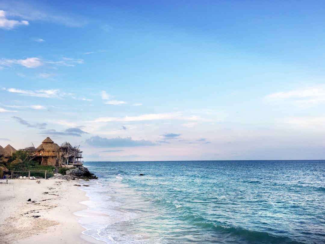
Even the Caribbean side, which most people write off as flat, can surprise you. During the winter, the Yucatan’s eastern tip picks up rare, high-energy swells from North Atlantic storms that cut through the protection of the Mesoamerican Barrier Reef. If you’re heading to the Gulf of California, keep in mind that the tides can shift as much as 20 feet in a single cycle, which completely flips the wave quality in just a few hours. Meanwhile, Nayarit relies on those seasonal tropical wind shifts, giving you glassy mornings before the afternoon breeze kicks up. Honestly, you have to be willing to track the wind and the bathymetry just as much as the swell forecast to really catch the best of it.
Scaling the Sierra Madre: Mountain Adventures Beyond the Beach
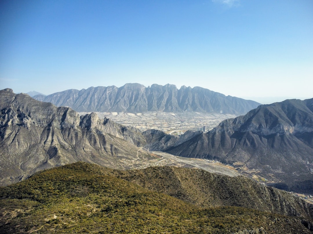
If you've spent any time chasing waves on the coast, you've probably looked up at the mountains and wondered what's happening behind that horizon. Most folks just see the beach, but honestly, the Sierra Madre is the real engine behind everything you're experiencing in the water. Those peaks aren't just scenery; they’re a massive, complex system that dictates the very sediment and river flow shaping the sandbars you're surfing down at the break. When you climb into the Sierra Madre Occidental, you’re looking at a canyon system four times larger than the Grand Canyon, where the weather shifts from alpine pine forests at the rim to a humid tropical jungle just a few thousand feet below. It’s wild how the range acts as a thermal buffer, often dropping the temperature by twenty degrees Celsius in just a few miles of climbing, which is a lifesaver when the coastal heat gets a bit too heavy.
The geology here is just as intense as the surf, driven by the Cocos Plate sliding under the North American continent to push up some of the most rugged terrain you'll ever navigate. Take the Sierra Madre Oriental, for instance, where the karst landscape has carved out the Sótano de las Golondrinas, a vertical abyss so deep you could drop the Chrysler Building inside it without hitting the top. Then you’ve got the giants like Pico de Orizaba, a stratovolcano reaching nearly 19,000 feet that holds one of the few remaining glacial caps in North America. It’s an orographic wall that forces Pacific moisture upward, creating a weather cycle that feeds the watersheds below. You might be focused on the surf, but the water you're riding is literally being filtered and managed by the cloud forests and glaciers tucked away in these high-altitude ranges.
I’m always struck by how unique the biodiversity gets when you move inland. You’ve got these temperate cloud forests—the bosques mesófilos—that actually pull water straight out of the clouds to keep the regional rivers flowing during the dry season. It’s the same story with the Monarch Butterfly Biosphere Reserve, where millions of insects manage a 3,000-mile migration just to hit the perfect thermal sweet spot in these mountains. Even the volcanoes tell a story, like the Nevado de Toluca with its two crater lakes sitting at 14,000 feet, which are honestly among the highest freshwater bodies on the planet. If you’re planning on heading up there, just remember that the terrain is as unstable as it is beautiful, especially with active giants like Popocatépetl constantly shifting the ground and enriching the soil for the valleys below.
Honestly, don't look at these mountains as just a place to hike when the swell goes flat. Think of the range as the backbone of the entire region, where the North American Monsoon drops sixty percent of the yearly rain to keep the whole ecosystem alive. Whether you're navigating the glacial scree on Iztaccíhuatl or just watching the sediment transport into the coastal estuaries, the connection between the peaks and the surf is undeniable. It’s a massive, living machine that’s far more interesting than your standard tourist map suggests. I’d recommend taking a few days to get into the high country; seeing how the geology creates those massive vertical drops right near the coast will change how you see the entire country. Just pack for every climate imaginable, because when you’re dealing with this kind of elevation, the weather doesn't wait for anyone.
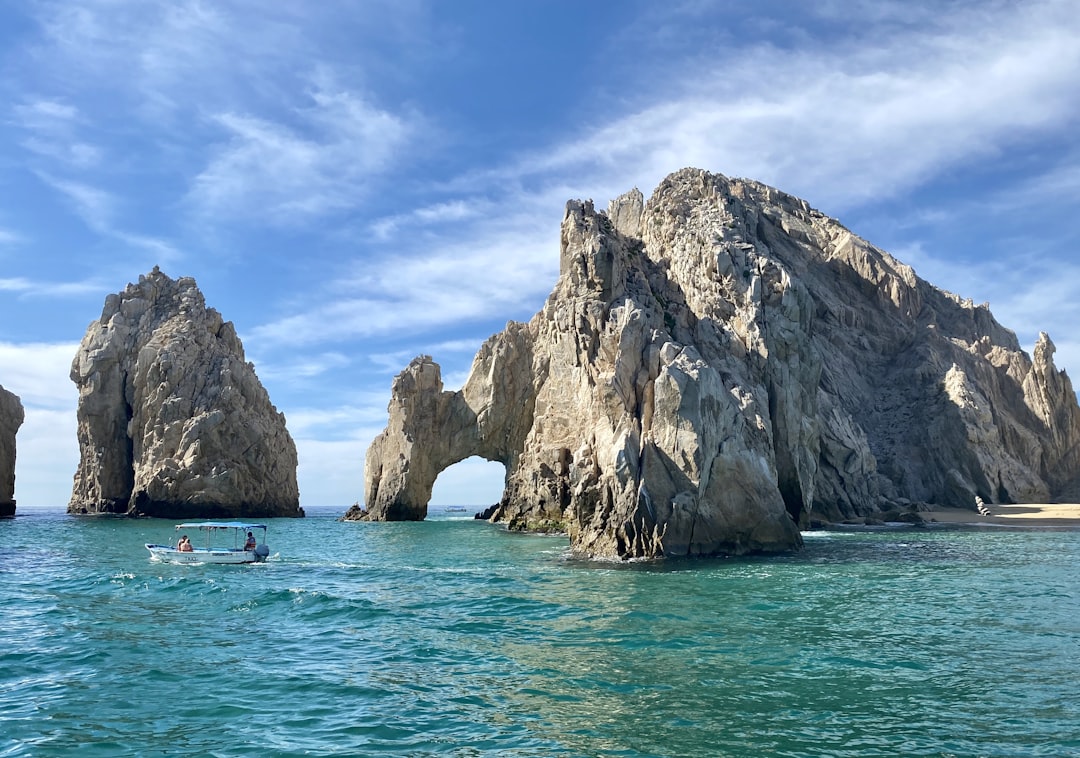
Baja California: Where Desert Landscapes Meet World-Class Surf
When you look at the Baja Peninsula, you aren't just seeing a stretch of sand; you’re witnessing a massive, slow-motion geological divorce where the land is literally tearing itself away from the Mexican mainland at about five centimeters every year. It’s wild to think that as you’re sitting on the beach, you’re on a fragment of crust drifting into the Pacific, driven by the same tectonic tension that carves out the deep-water channels responsible for those legendary long-period swells. Most folks see the desert and think it’s a barren wasteland, but that arid environment is the engine behind the surf. The fierce thermal updrafts rising off the sun-baked desert floor collide with the cold, dense air of the California Current, creating a meteorological filter that cleans up the wind and grooms the incoming energy into consistent, world-class waves.
Honestly, the way the coastal fog, or camanchaca, rolls in from the Pacific is the only reason this entire ecosystem functions. It’s this weird, beautiful contradiction where the moisture from the ocean feeds the desert flora, allowing life to persist in a place that gets less than ten centimeters of rain annually. If you head inland, you’ll find the Sierra de la Giganta, where you can literally climb up and find fossilized marine life embedded in the limestone, a physical reminder that these high-altitude peaks were once the seafloor. It’s these massive vertical shifts that manage the local microclimates, protecting the ancient rock art in the canyons while acting as a buffer that keeps the coastal temperatures stable enough for us to stay comfortable in the water for hours on end.
Think about it this way: you’ve got a high-energy marine environment on one side and an isolated, volcanic desert on the other, and the result is a massive, living laboratory. The lagoons of the El Vizcaíno Biosphere Reserve aren't just spots for gray whale nurseries; they’re hyper-saline environments that function as a natural buoyancy system for calves, which is just one example of how the geography here is uniquely tuned for life. Whether you’re looking at the botanical oddity of the twisted boojum trees or tracking the swell that’s traveled thousands of miles across the Pacific, you’re engaging with a landscape that’s far more dynamic than any map can suggest. I’d really encourage you to look past the break; once you understand how the desert heat and the deep-sea bathymetry are working together, you’ll start seeing the entire peninsula as a single, synchronized machine.
Nayarit and Beyond: Uncovering Mexico’s Under-the-Radar Adventure Hubs
When we look past the usual suspects of the Mexican coastline, the state of Nayarit reveals a fascinating, complex geology that honestly dictates every bit of the adventure you’ll find there. If you’ve ever wondered why the biodiversity here feels so much more intense than elsewhere, it’s because the region is essentially a masterclass in volcanic influence and hydrological engineering. Think about the Marieta Islands, which were hollowed out by past military activity to create that surreal, collapsed crater known as the Hidden Beach, but they’re also a critical sanctuary for the blue-footed booby. It’s wild to realize that these islands are actually one of the southernmost breeding grounds for the species, proving that the local ecology is far more resilient than it looks. When you get inland toward the volcanic highlands of Jala, you’ll find soil so rich in basalt that it produces corn cobs reaching 45 centimeters in length, a strange but perfect metric for the region's unique nutrient density.
Moving toward the coast, the Ameca River acts as a constant, shifting boundary between Nayarit and Jalisco, and the sediment it drops is the secret engine behind the high marine productivity you experience in the water. We also have the Marismas Nacionales, which is the largest mangrove system in the Mexican Pacific, covering roughly 200,000 hectares and acting as a massive carbon sink for the entire coast. These wetlands aren't just scenery; they are biological filters maintaining the salinity levels necessary for over 100 species of migratory waterfowl. If you’re into the historical side of things, check out the ruins of the Fuerte de la Contaduría in San Blas, which served as the key customs hub for Spanish galleons bound for the Philippines, a reminder that this area was a global crossroads long before it became an adventure hub.
Honestly, the way the climate behaves here is entirely defined by the Sierra Madre Occidental creating a distinct rain shadow, keeping the coastal zones noticeably drier than the peaks just a few miles away. You’re also seeing a landscape defined by ignimbrite rock—the remnants of prehistoric volcanic eruptions that buried the area in layers of ash and pumice. If you take the time to hike into the remote valleys, you’ll find ancient petroglyphs carved into these volcanic boulders, marking the old trade routes that pre-Columbian cultures used to navigate the mountain passes. It’s this deep connection between the volcanic soil, the mangrove estuaries, and the mountain corridors that makes Nayarit so much more than a typical beach destination. I’d suggest spending at least a few days exploring the transition from the La Tovara mangroves up into the Sierra de Vallejo biosphere, where the tropical dry forests are still protecting the last of the local jaguar population. It’s a dense, living landscape, and once you see how the hydrology and the geology fit together, you’ll realize why this area is effectively the hidden backbone of the Mexican Pacific.
Mixing Surf and Sierra: Creating the Perfect Dual-Sport Itinerary
If you’re planning to tackle a dual-sport trip that links the Pacific breaks to the high Sierra, you’ve got to respect the sheer physical reality of moving between these zones. We’re talking about crossing the Trans-Mexican Volcanic Belt, which is easily the most active concentration of stratovolcanoes in North America. You’ll feel the shift in your lungs almost immediately because the partial pressure of oxygen drops off a cliff once you start hitting that 2,000-meter climb into the Sierra Madre Occidental. It’s not just about the view; it’s a genuine physiological transition that catches a lot of folks off guard. You’ll be in boardshorts one hour and then looking at frost on pine needles the next, thanks to those wild thermal inversion layers that trap dense, cold air in the high-altitude valleys.
Think of the landscape as one giant, interconnected plumbing system where the water you see at the beach is intimately linked to the peaks above. The underground karst systems are incredibly efficient, often pushing freshwater runoff from those high summits all the way to the coastline in less than 48 hours. It’s a total trip to realize that the same geological force carving those mountain trails is simultaneously shaping the sandbars you’re surfing. A lot of these technical mountain routes actually follow ancient trade paths aligned with magnetic north, a testament to how indigenous cultures navigated this terrain long before we had GPS to bail us out. Honestly, it’s humbling to stand on a trail that’s been a corridor for centuries while knowing the coastal bathymetry beneath you might be shifting overnight due to seismic activity along the Riviera Nayarit fault lines.
If you’re really geeking out on the science of it, look for the ecotones—those distinct transition zones where the cloud forests meet the tropical jungles. You’ll notice the species richness is just off the charts because you’ve got two different climate regimes crashing into each other. It’s also worth noting that the soil in the volcanic highlands, especially near spots like Jala, is packed with magnesium and iron, which is exactly why the vegetation there looks so lush and grows so fast compared to the arid desert terrain on the coast. I’d suggest keeping a close eye on the wind, too, because that permanent orographic lift caused by moisture hitting the steep slopes of the Sierra is what really drives the mountain weather. Just remember that you’re moving through a landscape that is constantly adjusting itself, so stay flexible with your itinerary and always pack for that massive temperature swing.
Practical Tips for the Adventure Traveler: Staying Safe and Mobile in Mexico
When you’re planning a trip that mixes remote surf breaks with high-altitude mountain trekking, the logistics of staying safe and connected become just as important as the gear in your board bag. I’ve found that the most reliable way to navigate Mexico’s diverse terrain is to lean on the country’s own infrastructure, starting with the Angeles Verdes. These bilingual crews patrol federal highways in distinct green trucks and are essentially a gold standard for roadside support if your rental happens to falter in the middle of nowhere. Honestly, it’s worth sticking to the cuotas, or toll roads, whenever you can; they’re statistically better maintained, heavily patrolled, and they provide a much smoother, safer experience than the local free roads that often wind through unpredictable, less-monitored territory.
When you’re heading off the grid, don’t rely solely on your home carrier’s roaming plan, as it’s rarely enough for the deep rural reaches of the Sierra Madre or the coastal biosphere reserves. I always recommend grabbing a local Telcel SIM card for a dual-SIM setup, as their infrastructure is the most robust and actually reaches into those pockets where other providers just drop off. It’s also a good idea to download high-resolution topographic maps for offline use before you leave civilization, because once you drop below a ridgeline in a deep mountain canyon, those standard cellular-based map apps are going to fail you every single time. And if you’re carrying expensive camera or GPS gear, remember that the local power grid can be a bit jumpy during the monsoon season; a compact, high-quality surge protector has saved me from frying my tech more than once when the lights start flickering at a remote surf camp.
When it comes to personal security, my best advice is to keep a low profile by avoiding high-visibility luxury gear that acts like a beacon in busy transit hubs. I’ve started using discreet GPS tracking tags and a dedicated satellite messenger like a Garmin inReach, which operates on the Iridium network and keeps me connected even when the local towers are miles away. It’s also smart to keep your documents digitized in an encrypted cloud service, especially since the intense humidity of the tropics or the rapid temperature swings at high elevation can wreck physical paperwork in a heartbeat. Finally, if you’re hiring local guides for those big volcanic climbs, take the extra five minutes to verify their credentials against the official SECTUR registry. It sounds like a small step, but it’s the only way to know for sure that your guide is actually certified for the specific safety protocols required for that kind of high-altitude terrain.