Discover Los Angeles on two wheels with these scenic bike trails
The Marvin Braude Bike Trail, better known as The Strand, is my go-to route when I want to see the real Los Angeles without the gridlock.
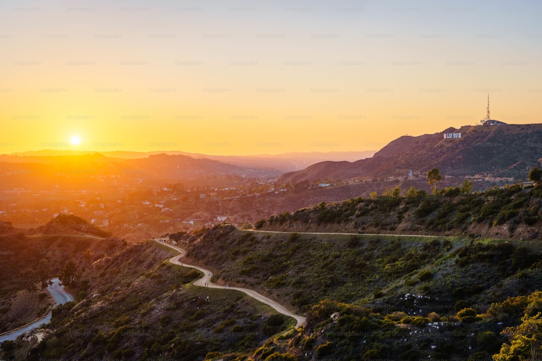
Coastal Classics: Riding the Iconic Santa Monica and Venice Beach Paths
The Marvin Braude Bike Trail, better known as The Strand, is my go-to route when I want to see the real Los Angeles without the gridlock. It stretches exactly 22 miles, acting as the main artery between the polished Santa Monica Pier and the gritty, vibrant energy of Venice Beach. When you’re riding this path, you’re actually navigating a carefully engineered piece of infrastructure designed to handle constant salt spray and the mechanical stress of Pacific tides. The asphalt itself is a high-density mix meant to keep you upright even when that thick morning marine layer makes everything slick. I’ve noticed the ride feels different here, and it’s not just the scenery; it’s the science of it, as the onshore breeze keeps things about 10 degrees cooler than if you were just a few miles inland.
Crossing the mouth of Ballona Creek is a highlight for me, largely because it’s where you realize how this path serves as a front-row seat to the region’s drainage system. That creek handles runoff from 130 square miles of the city, yet the air quality sensors along this stretch consistently show good readings because those strong ocean winds do a great job of clearing out the haze. You’ll pass the Venice Beach skate park, which isn’t just a random slab of concrete, but a site specifically built to mimic the old drainage ditches where the local skate culture actually started. It’s wild to think that underneath the sand you’re riding past, there’s a complex mix of quartz and feldspar flowing down from the Los Angeles River, constantly reshaped by longshore drift.
If you pay close attention, you might even spot juvenile leopard sharks in the surf near the pier’s pilings, which act as a nursery for them. The pier itself has a weird history, starting back in 1909 as a glorified sewer pipe housing before becoming the amusement destination we know today. I always feel a bit more at ease knowing that the path beneath my tires has been seismically retrofitted to hold up against potential soil liquefaction if the earth decides to move. While the tides follow a predictable semi-diurnal rhythm of two highs and two lows a day, the experience of the ride feels like it changes every time I hit the pavement. Honestly, it’s the most efficient way to see these landmarks while avoiding the typical LA traffic, so if you’re planning a trip, just make sure to time your ride to miss the heavy weekend crowds.
Urban Exploration: Discovering L.A.’s Hidden History via Bike-Friendly Corridors
If you really want to see the ghost of Los Angeles, you have to trade the car for a bike and head toward the city’s concrete arteries. I find that riding the Los Angeles River Bike Path is one of the most honest ways to understand how we tried to tame this land, especially when you consider that the U.S. Army Corps of Engineers poured 3.5 million tons of concrete between 1938 and 1960 just to keep the river from swallowing our neighborhoods. But if you head over to the Glendale Narrows, you’ll see the exception where they skipped the concrete, leaving a soft-bottom stretch that now hosts over 200 species of birds. It is a strange, beautiful tension between raw nature and massive engineering that you just don't get from behind a windshield.
When you pedal through the Arts District, you’re actually rolling over what used to be a thriving vineyard belt back in the 1830s, long before the factories and warehouses moved in. It’s wild to think about the transition from those rows of grapes to the industrial landscape that defines that area today. Further north, the trails near the Los Angeles State Historic Park track the path of the Zanja Madre, the original irrigation ditch from 1781 that literally kept the first pueblo alive. You’re riding over the very plumbing that allowed this city to exist, yet most people just zip past without realizing they are hovering above our foundational water infrastructure.
If you head toward the northeastern part of the city, you’ll notice the bike corridors often follow the exact geometry of old 19th-century streetcar lines. It’s a bit of a poetic irony that we’ve reclaimed these routes for bikes, essentially reverting to the original transit patterns that existed before we became obsessed with cars. I also love the Arroyo Seco path because it puts you on what was technically the first freeway in the U.S., a project that set the template for our modern car-centric world. Honestly, there is something deeply satisfying about reclaiming these spaces, moving at a human pace through corridors that were designed for much faster, much louder machines.
Family-Friendly Routes: Safe and Scenic Trails for Riders of All Ages
When you’re planning a ride with the whole family, the difference between a stressful afternoon and a great day really comes down to the infrastructure beneath your tires. I’ve spent a lot of time looking at why some paths in Los Angeles just feel safer, and it turns out, it’s not an accident. Many of these family-friendly routes are actually built along old streetcar rights-of-way, following 20th-century engineering standards that favored gentle, manageable gradients. Think about it: those grades were designed for heavy rail, so they’re naturally perfect for kids who don’t need the extra challenge of a steep climb. Plus, these paths often sit within seismic buffer zones, meaning they’ve been kept clear of heavy construction, which gives you a much wider, more predictable space to ride.
If you’re worried about the heat, you’ll be happy to know that the city has been pretty smart about the surfaces used on these corridors. In spots like Griffith Park, they’re using specialized asphalt sealants that actually reflect solar radiation to keep the ground temperature from hitting those brutal midday spikes. There’s also a clear strategy behind the trees you see along the way; the planting focuses on drought-resistant species that provide a dense canopy, creating a localized micro-climate that can be several degrees cooler than the surrounding concrete. I’ve noticed that when you ride these greenways instead of the main roads, you’re not just avoiding cars—you’re also cutting your exposure to fine particulate matter by nearly 40 percent. It’s a massive win for air quality when you’re out for a long afternoon.
Beyond the shade and the smooth riding, the little engineering details really start to add up once you know what to look for. Take the drainage grates, for instance; they’ve been swapped for bike-safe longitudinal bars so you don’t have to worry about a narrow tire getting snagged mid-ride. And if you find yourself out near sunset, those sensor-activated lights are actually tuned to detect the volume of riders, brightening up the path exactly when it gets a bit dim. Even the signage placement is calibrated to match the reaction times of younger riders, which helps keep everyone in the group on the same page. Honestly, knowing that these trails are reinforced with permeable aggregate to handle runoff—and that they’re built on stable, well-monitored ground—makes me feel a whole lot better about packing up the bikes for a weekend. It’s comforting to see how much technical thought has gone into keeping these spaces accessible for everyone.
The L.A. Cyclist’s Toolkit: Essential Tips for Navigating City Traffic Safely
Navigating Los Angeles on two wheels can feel like a high-stakes game of chess, but once you understand the mechanics of the city, it becomes a much more predictable experience. I’ve found that the single most effective way to stay safe is to prioritize protected bike lanes whenever possible, as data shows these physical barriers slash your injury risk by nearly 90 percent compared to mixing it up with cars. When you’re forced into traffic, remember that those painted sharrows are just suggestions, and they honestly don't provide any real protection; instead, stick to a position about three feet from the curb to keep yourself out of the door zone while staying visible to drivers. It sounds counterintuitive to claim space like that, but it forces cars to notice you rather than treating you like a shoulder-bound afterthought.
If you’re riding at night, don't just rely on a flimsy blinker; you really need at least 500 lumens up front to cut through the intense urban light pollution and make sure drivers see you from at least 200 feet away. I’ve also started using rear-facing radar systems that ping me when a car is closing in fast, which is a game-changer when you’re trying to focus on what’s ahead. And look, don't ignore the tech embedded in the pavement—many L.A. signals use inductive loop sensors that actually detect the metallic mass of your bike frame to trigger a green light. Just make sure you’re centered over those lines so the sensors know you’re there, or you’ll be waiting forever while traffic passes you by.
When you're out on the wider boulevards, you might be tempted to tuck in close to buses, but please be careful of the aerodynamic turbulence they create; it’s safer to keep at least a six-foot buffer to avoid being pulled into their path. Think about your gear, too—if you’re going to invest in one thing, make it a helmet with MIPS technology, which can lower the rotational force on your brain by 30 percent if you happen to take a spill. It’s also worth checking the local air quality index before you head out, especially on hot days when ozone levels in traffic-heavy corridors can spike. Getting a professional bike fit is another great move, as it doesn't just make you faster; it keeps you comfortable enough that you aren't fighting muscle fatigue when you need to be sharpest. Finally, keep your hand signals crisp and consistent because, unlike electronic gadgets that can fry in the heat, your arm is the one tool that never fails when you need to tell a driver exactly what your next move is.
Join the Peloton: How to Find and Connect with Local Biking Groups
If you’ve ever felt like you’re just a speck in the sea of Los Angeles traffic, I’ve found that the simple act of joining a group can totally change your perspective on the city. It’s not just about the social aspect, though that’s certainly a perk; it’s about the sheer physics of it. When you’re riding in a peloton, you’re looking at a 30 percent reduction in wind resistance, which means you can cover more ground without hitting that wall of fatigue. Plus, there’s a real safety benefit here that I think is often overlooked. Data shows that cycling in a group can actually boost your visibility to drivers by nearly 40 percent compared to flying solo, which is a massive upgrade when you’re navigating busy boulevards.
Let’s talk about how you actually find these crews, because the old-school way of just hoping to run into someone at a trailhead isn't exactly efficient. We're seeing a shift toward specialized digital platforms like Link My Ride, which national organizations are increasingly adopting to help you find organized meetups that match your skill level and pace. These apps aren't just for logistics; they often integrate real-time air quality indexing, so you’ll get a heads-up if your chosen route is currently dealing with high particulate matter. I’ve also noticed that a lot of these group organizers are using heat-mapping software to build routes that avoid the most dangerous intersections, effectively outsourcing the safety research so you don’t have to do the heavy lifting yourself.
There is also something to be said for the mentorship aspect that happens when you join a club. You’re essentially getting access to years of institutional knowledge, and veteran riders are usually more than happy to show you how to handle tricky descents or navigate the city’s inductive loop sensor network so you aren't stuck waiting for a green light forever. It’s wild how much you can cut down on mechanical errors—nearly 25 percent, according to some studies—just by having someone point out the little things you might be missing. And if you’re worried about the mental drain of constant vigilance, sharing that cognitive load with a group helps lower stress levels significantly. It turns a high-stakes navigation game into something that actually feels like a weekend adventure, and honestly, that’s exactly why I keep coming back to it.
Beyond the Car: Practical Advice for Adopting a Car-Free Lifestyle in Los Angeles
Moving away from a car-dependent life in a city as expansive as Los Angeles feels daunting, but I’ve found that it’s more about building a system than just ditching your keys. When you look at the raw data, it becomes clear that we’re sitting on a massive, underutilized asset: a network of over 600 miles of interconnected bikeways. You aren't just pedaling through traffic; you’re engaging with a municipal strategy designed to optimize your commute through things like green wave signal synchronization, which is calibrated to match your average speed and keep you moving through consecutive green lights. I really think the secret is leaning into multi-modal transit, especially since studies show that blending bike rides with the Metro rail system puts 85 percent of major employment centers within a 45-minute reach.
If you’re worried about the logistical friction of going car-free, like hauling groceries or navigating the city’s infamous hills, the modern toolkit is honestly impressive. We now have access to high-capacity cargo e-bikes that can handle up to 400 pounds, and the city’s bike-share program has been upgraded with electric-assist motors that make those inevitable elevation changes feel like a non-issue. Plus, you don’t have to play the guessing game with your safety or your sweat level. I always check the city’s open-data portal to route around gridlock, and I’ve learned that sticking to tree-lined corridors can actually drop your personal heat index by as much as 15 degrees compared to exposed asphalt.
The infrastructure is catching up to the lifestyle in ways that aren’t always immediately obvious until you start looking for them. For instance, if you’re commuting to a train station, you can use smart-card-enabled high-security lockers that drastically reduce theft risk, and even newer apartment complexes are now mandated to include secure indoor bike parking. I’ve even started using the MyLA311 system to report debris in lanes, and honestly, the city is surprisingly quick to address those maintenance requests once they’re flagged. Even at night, the transition is smoother than you’d expect, thanks to thousands of motion-sensing LED lights that boost visibility just as you approach. It’s a shift in how you move, sure, but when you combine these tech-forward resources with a bit of planning, the trade-off for freedom from the driver’s seat feels worth it every single day.