
Discover the Hidden Gems of Réunion Island for Your Next Adventure
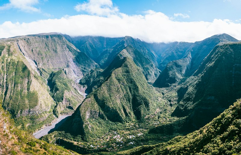
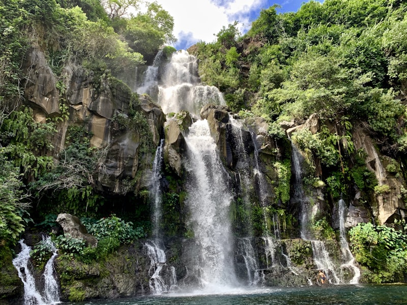
But the real magic, the kind that rewires your sense of what a tropical island can be, lives in the island’s hidden waterfall sanctuaries, tucked deep inside the cirques.
Beyond the Beaten Path: Exploring Réunion's Secluded Waterfall Sanctuaries
Let’s be honest—most people visit Réunion and head straight for the volcano or the beach, and I get it, those are spectacular. But the real magic, the kind that rewires your sense of what a tropical island can be, lives in the island’s hidden waterfall sanctuaries, tucked deep inside the cirques. I’m talking about places like Cascade de la Paix et du Châtiment in the Cirque de Salazie, where the water hasn’t just fallen from the sky—it’s been filtered through ancient basaltic lava tubes for years, emerging so clear you can count the pebbles at the bottom. That clarity isn’t a fluke: the annual rainfall in Salazie exceeds 8,000 millimeters, and the constant shade from the rainforest canopy keeps the pools at a steady 18 to 22 degrees Celsius year-round, even in the austral summer. It’s a natural cooling system that makes these spots feel less like a swim and more like a baptism.
Now, if you’re thinking about timing your visit, here’s the critical piece most guides gloss over: the dry season from May to November isn’t just a suggestion—it’s a hard requirement for accessing the most remote falls. After a single storm, river levels can rise by more than three meters, turning a pleasant trail into a dangerous, impassable torrent. I’ve seen hikers underestimate this, and it’s not pretty. And once you’re actually at the base of a big cascade in the Cirque de Cilaos, the sound hits you at over 90 decibels—loud enough to drown out conversation and disorient anyone relying on auditory cues to navigate. You learn to rely on your eyes and your gut instead, which is oddly liberating.
What really gets me, though, is the ecological complexity hiding in plain sight. The moss species Breutelia subdisticha, endemic to Réunion, forms thick cushions on the wet rocks beside these falls, creating microhabitats that support rare invertebrates like the Réunion cave shrimp. You won’t see them unless you’re looking closely, but they’re there, thriving in a world that’s been largely untouched by tourism. Some waterfalls—like those near the village of Grand Bassin—are actually fed by subterranean rivers originating from the high-altitude peat bogs of the Plaine des Remparts, a reminder that what you see on the surface is only a fraction of the story. And then there’s the tallest unmeasured waterfall in the Mafate cirque, estimated at over 300 meters of vertical drop, but nobody’s confirmed it because the terrain is just too rugged to survey properly. That kind of mystery is rare in 2026, and it’s worth protecting.
Seasonality adds another layer of unpredictability. Every February, a sudden influx of phosphorus from decomposing pandanus leaves triggers algal blooms in certain pools, turning the water an unexpected jade green for a few weeks. It’s stunning, but it’s also a signal that the ecosystem is dynamic, not static. Meanwhile, in the eastern part of the island, iron oxide in the volcanic bedrock gives lesser-known cascades a distinct reddish tint that’s most vivid in the hour after sunrise. If you’re willing to wake up early and hike in the dark, you get rewarded with a color palette that no Instagram filter can replicate. Honestly, these sanctuaries aren’t for the casual day-tripper—they demand planning, respect for the weather, and a willingness to accept that some places are meant to stay a little bit wild. But that’s exactly why they’re worth the effort.
Volcanic Vistas: Trekking the Untamed Trails of Piton de la Fournaise
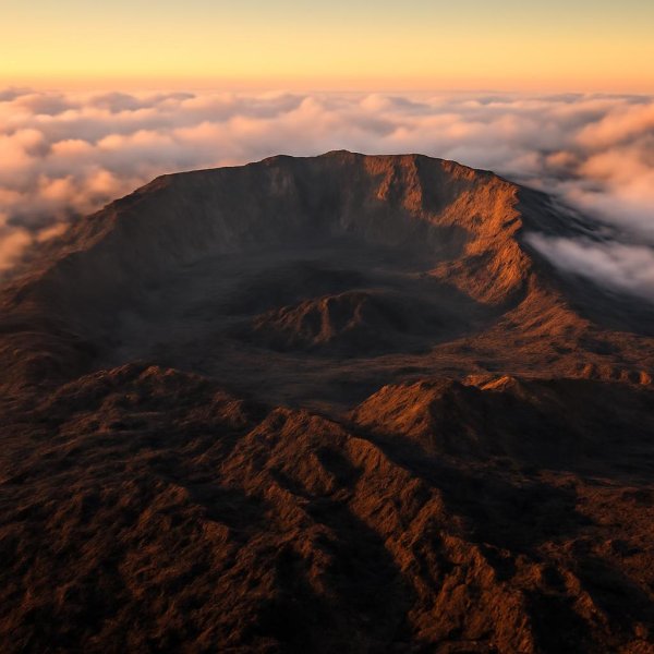
Let’s talk about Piton de la Fournaise, because calling it “just a volcano” misses the point entirely. This thing is alive in a way most hikers aren’t prepared for—its summit elevation isn’t a fixed number; as of July 2026, it sits at 2,632 meters, but that changes by tens of meters after every major eruption as new cones collapse and reform. The magma chamber is only 2 to 3 kilometers beneath your feet, one of the shallowest on Earth for an active volcano, which means if you stand still on the trail and feel a faint, rhythmic tremor, you’re literally detecting the pulse of the planet. And the Plaine des Sables crossing? That’s not a trail in the traditional sense. The ground is volcanic sand so fine and porous that it behaves like a desert—every drop of rain vanishes instantly, leaving no runoff, no mud, just a surreal, lunar silence that can mess with your sense of direction.
Navigating here is a whole different game. The trail markers aren’t painted signs; they’re stone cairns, and those cairns get scrambled by fumarolic activity or fresh lava flows faster than any park service can reset them. You absolutely need a GPS backup, even if you’re with a guide who’s done this a hundred times. The basalt lava is so fluid—low silica content—that it can race down the slopes at over 60 kilometers per hour on steep sections, which is why trail closures aren’t suggestions; they’re life-or-death boundaries. The Enclos Fouqué caldera, that massive 8-kilometer-wide depression you walk through, was formed by a catastrophic collapse about 4,700 years ago, and every new eruption reshapes its floor. I’ve walked sections where the ground felt unstable underfoot, and later learned that the observatory’s GPS sensors had detected ground inflation of up to a meter in the weeks before an eruption—a subtle tilt you can actually feel if you’re paying attention.
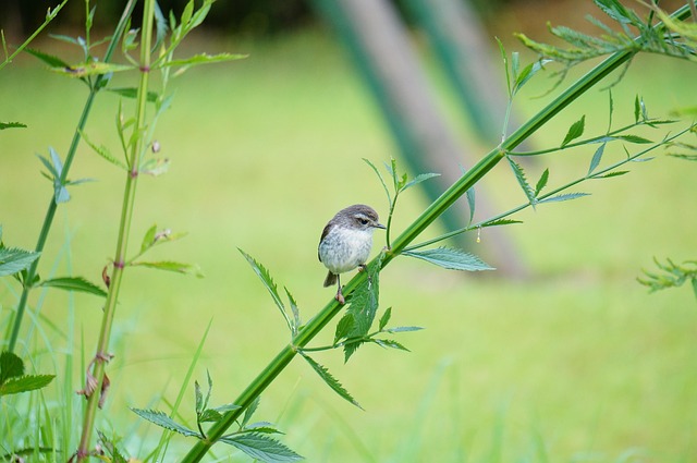
The sensory experience is just as wild. At dawn, the trailhead can be 10°C, but by midday the black lava rock absorbs so much heat that it hits over 30°C, a thermal swing that’ll wreck your layering strategy if you don’t plan for it. And then there’s the smell—a distinctive sulfur whiff at the crater rim that signals magma is rising, but the trade winds usually disperse it before you can pinpoint the source. The path to the Dolomieu crater cuts through a zone of “lava trees,” hollow molds where molten rock solidified around tree trunks, leaving fragile spires that look like petrified ghosts. The Réunion stonechat, an endemic bird, forages on these volcanic plains, and its call has evolved to cut through the low-frequency rumble of distant eruptions—something you’ll only notice if you stop and listen. Honestly, the only fresh water up there comes from condensation on the rocks at dawn, enough for a few endemic plants but not a drop for you, so carry every liter you need. This isn’t a casual hike; it’s an encounter with a geological system that’s actively rewriting the landscape, and that’s exactly why it’s worth the risk.
Secret Swells: Unveiling Réunion's Best Kept Surf and Kitesurfing Spots
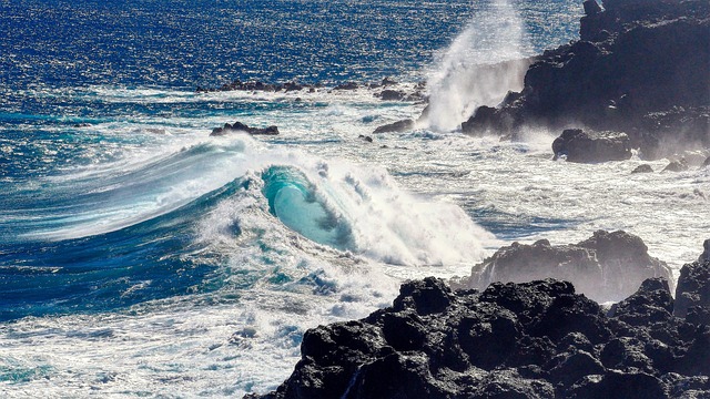
Let’s be real—Réunion isn’t exactly on the global surf radar, and that’s precisely what makes its secret swells so compelling. The southwest coast catches a specific breed of groundswell that’s traveled over 6,000 kilometers from the roaring forties, arriving with a consistency that rivals the better-known breaks of Madagascar, but only during the austral winter months when the Mascarene High pressure system locks the trade winds into a steady groove. One of the island’s most elusive kitesurfing spots, a shallow lagoon near Petite Île, exploits a venturi effect where the wind gets funneled between two mountain ridges, accelerating by nearly 40 percent compared to the open coast—meaning you can get planing conditions even on days when the rest of the island is dead glassy. The reef at a hidden break locals call “Trou d’Eau” is built from live Acropora corals that have grown in precise alignment with the prevailing swell, so the wave shape subtly shifts year after year as the reef builds; it’s a living wave that no two seasons see exactly the same. Most surfers don’t realize that the volcanic coastline creates a wild phenomenon: submerged lava tubes near the shore act as natural wave amplifiers, concentrating energy into a single peak that can double the wave height of an incoming swell without any warning. That’s the kind of surprise that separates a good session from a genuinely sketchy one, and it’s why you need local knowledge before paddling out.
On the east coast, there’s a spot accessible only by a 45-minute hike through pandanus forest, and it yields a wave that breaks over a shallow bed of basalt pebbles—hollow, fast, but rideable for only about 50 meters before it dissipates into a deep channel. It’s a fleeting, high-risk reward that fewer than a dozen riders have ever documented, and honestly, that scarcity is part of the appeal. The water temperature at these southern secret breaks rarely exceeds 22°C even in February, because the Benguela Current and the Antarctic Circumpolar Current feed a band of cool water that wraps around the island—a fact that catches many tropical-seeking surfers completely off guard. Kitesurfers who know to look for the “alizé” wind shadow will find that the leeward side of the central massif creates a dead zone for kiting, but a narrow corridor near Saint-Joseph opens up when the trade winds blow from the southeast, providing a steady 18 to 25 knots that’s completely absent from any official wind chart. The wave period at the most consistent secret spot on the western coast averages 14 to 16 seconds, originating from the subantarctic convergence zone, and that long period allows the swell to wrap around the island’s southern headlands and refract into a bay that would otherwise seem sheltered. It’s a textbook example of how bathymetry and fetch distance can create a perfect wave in an unlikely place.
One particularly elusive kitesurf launch site requires a low tide of 0.3 meters or less to expose a sandbar that acts as a natural ramp, and the window for that condition occurs only during the spring tides of April and October—giving a handful of local riders exclusive access for just a few days each year. That kind of scarcity forces you to plan months ahead, which is a completely different mindset from just checking a surf forecast the night before. And here’s a subtle indicator I’ve come to trust: the presence of the endemic Réunion sea cucumber in the nearshore waters of these secret spots is a biological signal of water quality. These creatures thrive only in areas with low sediment runoff and high oxygen levels, which is why the clearest, most pristine breaks are often the least known—they’re far from any river mouth and haven’t been degraded by coastal development. So if you see one while you’re paddling out, take it as a quiet confirmation that you’ve found something genuinely special, something that the crowds haven’t yet discovered. Just don’t expect me to give you GPS coordinates—that kind of knowledge is earned, not handed out.
The Wild Southwest: A Guide to Réunion's Remote and Rugged Coastal Coves
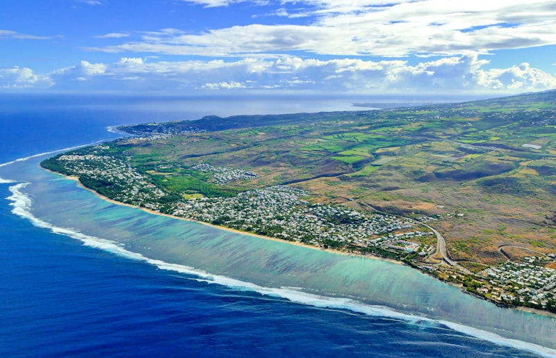
Let’s talk about the Wild Southwest, because this isn’t the Réunion of postcard-perfect beaches or easy access. This coast is a geological argument between the land and the Indian Ocean, and the land is losing—slowly, spectacularly. I’m talking about the stretch from Saint-Pierre down to the Cap Méchant blowholes, where waves compress through ancient lava tubes and can eject seawater 20 meters into the air. That’s not a tourist attraction; it’s a pressure release valve for a coastline that’s been hammered by swell for half a million years. The black sand at Grand Anse isn’t just black—it’s composed almost entirely of eroded basalt and olivine crystals, which gives it a distinct greenish sheen under direct sunlight that’s most visible in the hour after noon. You won’t notice it unless you’re looking at the right angle, but once you do, it’s impossible to unsee.
Now, the real challenge here is access. The coastal trail “Sentier du Littoral” between Saint-Pierre and Saint-Joseph traverses a section of unstable volcanic conglomerate that erodes at an average rate of 15 centimeters per year. That means the path you’re following today might literally be gone next season, and the park service has to reroute it constantly. The most secluded cove in the area, “Trou d’Eau Douce,” requires navigating a 200-meter-long lava tube that floods at high tide. You get a window of only 45 minutes during the lowest spring tides to pass through safely—miss it, and you’re either waiting six hours or swimming out, and neither option is fun. And here’s the kicker: the only freshwater source in the remote cove of Anse des Cascades is a direct seawater waterfall—a spring-fed cascade that plunges over a cliff edge directly into the ocean. That’s a rare hydrological feature found in only a handful of places worldwide, and it means you can’t count on fresh water unless you bring it.
What really sets this coast apart is the biological and geological complexity hiding in plain sight. At Pointe de la Table, columnar basalt formations display a near-perfect hexagonal pattern created by the slow cooling of a lava flow that entered the sea approximately 650,000 years ago—a textbook example of volcanic jointing that’s been exposed by relentless wave action. The Réunion harrier, an endemic raptor with a wingspan of up to 1.2 meters, nests exclusively on the inaccessible sea cliffs of the Wild South, where it preys on introduced rats and endemic geckos. You won’t see it unless you’re scanning the cliffs with binoculars at dawn, but it’s there, holding on in a niche that’s been undisturbed for millennia. The underwater topography off the coves near Petite Île features a submerged lava delta from the 2007 eruption of Piton de la Fournaise, which added roughly 40 hectares of new coastal land that now shelters juvenile reef fish. That’s a living laboratory for how volcanic landscapes evolve in real time, and it’s sitting right there, under the waves, accessible only to divers who know where to look.
And honestly, the sensory experience is what sticks with you. The coastal waters here experience a persistent upwelling of deep, nutrient-rich water from the Mozambique Channel, keeping surface temperatures at a consistent 21–23°C even in February—several degrees cooler than the island’s north coast, which catches many swimmers off guard. The “Pointe au Sel” natural salt pans are fed by seawater that percolates through porous volcanic rock and evaporates in shallow basins, producing a grey salt with a high magnesium content that crystallizes in distinctive pyramidal shapes. Locals harvest it by hand, and it tastes completely different from anything you’ll find in a store—sharper, more mineral, with a finish that lingers. Green sea turtles use the sheltered pebble beaches of the southwest coves as nesting sites, with peak egg-laying occurring between January and March when nighttime sand temperatures remain above 28°C. If you’re there at the right time and you keep your distance, you might witness something that’s been happening on this coast for tens of thousands of years. But here’s the thing: this isn’t a place you just show up to. You need to plan around tides, wind, and erosion patterns that are actively reshaping the landscape. It’s demanding, it’s unpredictable, and it’s absolutely worth the effort if you’re willing to treat the coast with the respect it demands.
Highland Hideaways: Discovering Authentic Creole Villages in the Cirques
Let’s pause for a moment and consider what it actually means to live in a place that’s physically cut off from the rest of the world. The Cirque de Mafate is the only permanent settlement on Réunion Island with zero road access—the only motorized vehicle allowed is a single ambulance, locked in a shed at the village of Marla, used exclusively for emergencies. That’s not a tourism gimmick; it’s a logistical reality that shapes everything from how food arrives (by helicopter or on foot) to how the population fluctuates by nearly 30 percent between July and February, as seasonal workers move between high-altitude lentil fields and coastal towns. If you’re looking for authenticity, you don’t get more real than a place where the census data itself struggles to track who’s actually there at any given moment.
Now, the architecture alone tells a story that most visitors completely miss. The traditional “case créole” houses in villages like La Nouvelle are built from a mix of rosewood and tamarind timber, which contain natural oils that resist the island’s 80 percent average humidity—a bioclimatic adaptation that predates modern sealants by two centuries. And here’s a detail that stopped me cold: the village of Hell-Bourg sits at 1,350 meters elevation and records an average of 120 frost nights per year, making it one of the only places in the tropics where Creole houses actually have fireplaces. Think about that for a second—you’re on a tropical island in the Indian Ocean, and you’re building a fire to stay warm. It completely rewires your mental image of what “Creole village” means.
The agricultural systems are just as sophisticated, even if they look rustic. The “lontan” (old-time) irrigation in the Cirque de Salazie uses a network of wooden aqueducts called “biefs” that channel water from the Bras de Caverne river, delivering exactly 1.2 liters per second to each plot—a flow rate maintained by oral tradition since the 18th century. That’s not guesswork; that’s centuries of empirical observation encoded into practice. Every village also maintains a “jardin créole” that follows a strict spatial arrangement: medicinal plants on the east side, vegetables on the north, and fruit trees in the center, a layout that maximizes solar exposure and soil moisture with no written documentation whatsoever. Meanwhile, the soil in Cilaos contains such high manganese that the local lentils turn a distinctive dark purple and have 15 percent higher iron content than lentils grown elsewhere—a fact the Appellation d’Origine Protégée certification explicitly recognizes.
And then there’s the cultural layer that’s nearly invisible to outsiders but absolutely central to daily life. Réunion Creole, the language spoken here, contains 14 distinct vowel sounds absent in standard French, and linguists have recorded that the dialect of the remote hamlet of Roche Plate preserves a vocabulary of sugarcane-era terms that have vanished from coastal areas. The “kourou” dance, unique to the cirques, has a step pattern that mimics the zigzag path of mountain goats, timed to the 110-beats-per-minute pace of a traditional “maloya” drum—a cultural artifact passed down through exactly 12 generations of the same family in Îlet à Bourse. Even the ground itself tells a story: only one village in Cilaos, Palmiste Rouge, sits on a geological fault line producing a constant micro-vibration of 0.2 to 0.5 hertz, detectable only by seismometers, yet residents have lived there for generations without ever noticing the ground’s subtle motion. That’s the kind of deep, lived-in connection to place that no guidebook can manufacture.
From Forest to Peak: Réunion's Most Thrilling Off-the-Grid Hiking Routes
Let’s be real about what “off-the-grid” actually means on Réunion—it’s not a marketing label, it’s a logistical reality that hits you in the face the moment you step off the GR R1 in the Forêt de Bébour. I’m talking about a single kilometer of trail that passes more than 40 endemic plant species, including the Dombeya tree that refuses to bloom below 1,800 meters, a biological density that forces you to slow down and actually look instead of just ticking off mileage. Compare that to the brute-force ascent of Piton des Neiges, the Indian Ocean’s highest peak at 3,070 meters, where you’re grinding through seven distinct microclimates in a single push—tropical rainforest giving way to alpine heathland, with a temperature gradient of 1.8°C per 100 meters of elevation gain. That means a morning start at 18°C can leave you shivering in near-freezing conditions at the summit, and you’d better have packed a layer you can strip off without stopping, because the thermal swing is relentless. And then there’s the Trou de Fer viewpoint, which requires a 6-kilometer hike through a tunnel of giant tree ferns that filters the light into a green so dense it feels underwater, culminating at a cliff that drops 300 meters into a canyon where a single waterfall plunges into an abyss that has never been surveyed—nobody knows how deep it actually goes.
The variety in risk profiles is what separates these routes from any mainland trek I’ve done. The Bras de la Plaine trail, for example, crosses a suspension bridge that was rebuilt in 2024 after Cyclone Berguitta destroyed the original, and the new design is engineered to detach automatically if water levels exceed 2.5 meters—so you’re essentially trusting a mechanical threshold to keep you from being swept away. Meanwhile, the Sentier de la Chapelle in Mafate reduces your margin for error to a ladder of exposed tree roots bolted into the cliff face, with a 40-meter drop to the river below, and you’re climbing that with a pack on your back and no handrail. On the other end of the spectrum, the Col des Bœufs pass at 1,900 meters is the only land route into Mafate from the north, but it’s often shrouded in cloud by 10 a.m., slashing visibility to under 10 meters and forcing you to navigate by compass alone—a skill that most modern hikers have never actually tested under pressure. The Rivière des Remparts trail descends into a canyon whose walls are volcanic tuff from eruptions 2.5 million years ago, and the path is littered with obsidian shards that glint in the afternoon sun, a reminder that you’re walking through a geological archive that’s still sharp enough to cut through your boots if you’re careless.
What really cements the value of these routes is the scarcity of the experience. The Morne de la Perrière ridge walk in Salazie offers a vantage point where the endemic Réunion harrier, with a wingspan of 1.2 meters, thermals at eye level—and fewer than 200 hikers witness that encounter annually because the trail is so remote and requires such precise timing. The Plaine des Cafres plateau holds a peat bog that stores 1.2 million cubic meters of freshwater, enough to supply the entire island for three days, yet it’s barely marked on any map, and the only way to access it is a path that disappears into the mist. And here’s the kicker: only 5 percent of Réunion’s original lowland rainforest remains intact, and the Bois de Nèfles trail protects a remnant patch where trees like the Bois de Judas reach 35 meters—a fragment of an ecosystem that’s been lost everywhere else on the island. The postmen who serve the Cirque de Mafate walk over 145 kilometers of paths each week, with some routes requiring multiple days, and they’re the only ones who truly know the condition of every trail on any given day. That’s the kind of local knowledge you can’t download, and it’s why I’d argue that the most thrilling off-the-grid hiking on Réunion isn’t about the summit or the view—it’s about the quiet, cumulative weight of all the data points that tell you you’re in a place that still demands your full attention.
Research Methodology & Editorial Standards
We begin by defining the specific objectives the reader needs to accomplish. Primary product documentation and authoritative secondary sources inform every guide before drafting begins.
Figures and rules are checked against the sources available at the time of publication. Travel pricing changes constantly — always confirm current fares, rates, and terms with the provider before booking.