Discovering the Ancient and Sacred Landscapes of Uluru Kata Tjuta National Park
When you walk through the shadows of Uluru, it’s easy to get caught up in the sheer scale of the rock, but the real story here is about the people who have called this place home for over 30,000 years.
Understanding the Spiritual Significance of the Anangu People
When you walk through the shadows of Uluru, it’s easy to get caught up in the sheer scale of the rock, but the real story here is about the people who have called this place home for over 30,000 years. The Anangu people don't just live on this land; they operate under Tjukurpa, a framework that acts as both a spiritual belief system and a practical code of law. Think of Tjukurpa as the bedrock for every social and environmental decision they make, effectively governing their entire world. It’s a living library where every geological feature isn't just a rock formation but a tangible representation of ancestral beings who shaped the earth. When we try to grasp this, we have to let go of the idea of a history book and instead imagine a complex, oral narrative that has stayed remarkably consistent for thousands of generations.
That 1985 handback of the land was a total game changer, shifting the legal narrative from colonial ownership to an official recognition of the Anangu as the true stewards of their territory. It changed everything about how we visit today. For instance, the 2019 decision to ban climbing wasn't some arbitrary rule meant to annoy tourists; it was a firm stand against the desecration of a space where ancestors are still considered present. When you look at the landscape through their eyes, climbing isn't an adventure—it’s a violation. It forces you to realize that this isn't a theme park or a playground, but a site of intense spiritual gravity that demands a different kind of engagement from us.
If you really want to understand what's happening here, you have to look at the practical side of their culture, like their traditional fire management. By using controlled burns, they keep the desert ecosystem in balance, which is a masterclass in biodiversity that Western science is only just beginning to truly appreciate. It’s a reminder that their "old" ways are often more sophisticated than our modern attempts at conservation. So, when you visit, try to move away from the urge to conquer or capture the perfect photo. Instead, lean into the idea of deep listening—a practice of observation that puts connection over physical presence. It’s a quiet, respectful shift, but it’s the only way to genuinely honor the reality of this ancient, living landscape.
The Geological Marvels: From Uluru’s Monolith to the Domes of Kata Tjuta
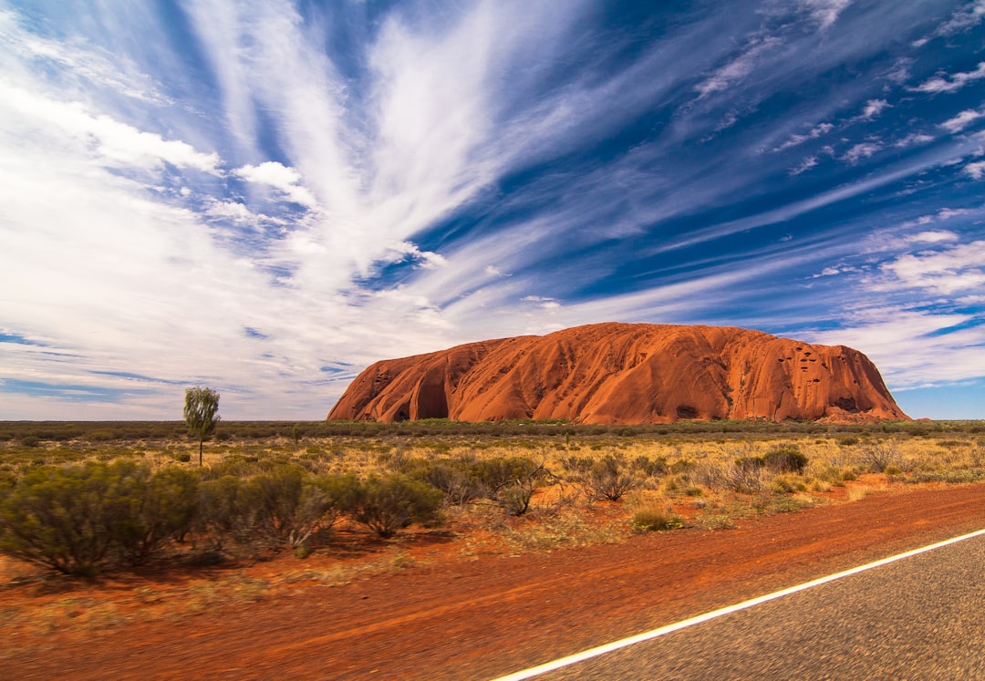
Let’s pivot to the literal foundation of this region, because you can’t fully grasp the scale of what we’re looking at until you look past the surface. While everyone calls Uluru a monolith, it’s actually an inselberg—a residual hill that stands its ground while the surrounding plains have long since eroded away. Here is the part that blows my mind: what we see rising 348 meters above the desert floor is essentially just the tip of the iceberg, with the vast majority of its mass sitting roughly 2.5 kilometers underground. It’s composed of arkose, a specific type of sandstone rich in feldspar, which is the secret behind that intense, iron-oxidized red glow we all recognize.
If you head over to the domes of Kata Tjuta, the geological story shifts entirely. Instead of one solid block, you’re looking at 36 distinct domes spread across 21 square kilometers, made of a rugged conglomerate of basalt and granite boulders held together by a sandy matrix. Think of them as the stubborn leftovers of an ancient alluvial fan system that once stretched across this basin. About 550 million years ago, tectonic shifts during the Petermann Orogeny literally tilted these horizontal riverbeds 90 degrees, forcing them onto their sides and creating the vertical structures we walk among today.
It’s easy to look at these massive features and assume they’ve always been this way, but they are constantly being refined by the desert itself. You’ve got this persistent cycle of thermal expansion and contraction—basically the rock heating up and cooling down—that causes the outer layers to flake off through exfoliation, which is exactly why the domes look so rounded and smooth. And because they’re so massive, they actually generate their own microclimates. If you look closely at the shaded crevices, you’ll find little pockets of water and shelter that support desert-adapted life that couldn't survive anywhere else in the surrounding heat. It’s a harsh, slow-motion engineering project that’s been running for hundreds of millions of years, and honestly, standing in the middle of it makes you feel pretty small in the best way possible.
Respecting Tradition: The Shift Toward Culturally Sensitive Tourism
Let’s pause for a moment and reflect on what it actually means to be a guest in a place like this. When we travel to sites of immense historical or spiritual weight, we often fall into the trap of being passive consumers, but there’s a genuine shift happening globally toward what I’d call bio-cultural tourism. It’s not just about snapping a photo anymore; it’s about acknowledging that our presence has a footprint that goes far beyond the physical. We’re seeing destinations from the Maldives to the high peaks of Bhutan start to formalize strict codes of conduct, and honestly, that’s a good thing. These protocols—whether they involve specific dress codes or respecting zones where cameras simply shouldn't go—are moving us away from extractive habits and toward a model of true co-governance where local communities actually hold the keys to their own land.
Here is what I think is the most compelling part of this change: the data actually backs it up. Research shows that when you engage in even a little bit of pre-visit preparation, your entire experience changes. You aren't just ticking a box on a bucket list; you’re building an emotional bridge to the landscape. It turns out that when we trade the "conquer and capture" mentality for something closer to deep listening, we end up feeling more satisfied, not less. I’ve noticed that the most memorable trips I’ve taken weren't the ones where I saw the most, but the ones where I was guided by indigenous interpretations that forced me to see the world through a different lens.
It’s easy to feel like these new boundaries are just another set of rules to navigate, but look at it as a way to protect the intangible. By prioritizing oral history and traditional knowledge over the quick gratification of a tourist trap, we’re helping keep these places alive for the next generation. When communities set their own thresholds for tourism, they’re essentially deciding what’s sacred and what’s shared, and that’s a form of agency we should be supporting. It’s a bit of a recalibration, sure, but if it means leaving a place with its dignity and ecology intact, then it’s a trade-off I’m more than happy to make. I truly believe that when we show up with this level of intention, we stop being outsiders and start becoming respectful participants in a story that’s been unfolding for thousands of years.
Decoding Ancient Rock Art and Tjukurpa Creation Stories
When you stand before the rock art at the base of Uluru, it’s tempting to treat it like a static museum exhibit, but that’s missing the point entirely. Think of these panels not as fixed historical snapshots, but as a living, breathing archive that the Anangu have maintained through ritualized repainting for millennia. It’s a sophisticated layering technique where pigments are reapplied over time, ensuring the narrative stays vibrant rather than fading into the past. Honestly, looking at these surfaces is like reading a stratigraphic history of cultural shifts, where newer art occasionally overlaps older depictions to record environmental changes or tribal movements. It’s fascinating to realize that some of these charcoal drawings date back 30,000 years, offering us a direct, tangible link to the earliest human inhabitants of the desert.
If you look closely, you’ll notice that these aren’t just decorative; they function as complex mnemonic maps. Those concentric circles and undulating lines are actually visual ledgers, encoding precise geographic coordinates and the locations of vital water sources necessary for survival. It really changes how you see the landscape when you realize that these walls are basically three-dimensional topographic guides. Scientists have even analyzed the ochre, discovering that the materials were transported over hundreds of kilometers, which proves there were extensive, complex trade networks operating across the interior long before we arrived. It’s clear the Anangu had a massive, sophisticated grasp of their surroundings, even using heat-treated hematite and goethite to achieve specific colors for ceremonial significance.
What really hits home for me is how these sites serve as a legal framework, not just an aesthetic one. Certain panels are actually solar-aligned, showing a deep, ancestral understanding of celestial movements that dictated seasonal life. You’ll also find stencils of human hands and tools in sheltered alcoves, which provide unique biometric data about the stature and technology of these ancient people. It’s a bit humbling to consider that these artistic expressions act as a legal document, delineating land rights and social responsibilities that the Anangu still uphold in their land management today. We’re essentially looking at a record of survival and governance that has remained consistent for thousands of generations, and honestly, it makes every other historical map I’ve seen feel a bit thin by comparison.
Exploring the Red Centre: Essential Tips for Navigating the National Park
Navigating the Red Centre requires a shift in how you think about outdoor exertion because the environment here is far more sensitive than your average hiking trail. If you're planning a trek, you have to be mindful that the soil under your boots is often a living crust of cyanobacteria and lichens, which can take decades to recover if damaged by a single stray step. Staying on marked tracks isn't just a suggestion; it’s a necessity to protect the fragile burrows of endangered creatures like the marsupial mole. You’ll also want to watch the thermometer closely because diurnal temperature shifts are brutal, with surface rocks capable of swinging 60 degrees Celsius in a single day. When the summer heat peaks, air density drops enough to place real, unexpected strain on your body, so take the park's rule of carrying one liter of water for every hour of walking as a hard requirement rather than a loose guideline.
It's helpful to realize that this landscape is a masterclass in thermal engineering, from the ancient gnamma holes—natural, debris-sealed basins that keep water from evaporating—to the way the park’s walking paths are precisely graded to manage heavy rainfall without causing erosion. The UV radiation here is consistently extreme, often outpacing coastal areas because of how the light bounces off the pale, high-albedo desert sands, so don't skimp on protection. While you're out there, look past the obvious and consider the hidden complexity of the biology; beneath the surface lie ancient groundwater aquifers that support species that haven't seen light in millions of years. Even the vegetation is playing a long game, with over 400 species waiting in a state of seed dormancy for as long as a decade until the exact right moisture levels trigger them to bloom.
If you’re wondering how the park stays so resilient against the constant threat of fire, the answer lies in the "fire-mosaic" management strategy that creates a patchy landscape, effectively acting as a natural buffer against catastrophic burns. It’s a sophisticated system that researchers track using remote, solar-powered acoustic sensors to keep tabs on rare desert fauna without us needing to crowd their space. Think of your visit as a partnership with a highly tuned system that's been balancing itself for eons. By moving with intention and respecting those physical boundaries, you’re not just avoiding a logistical headache; you’re making sure this place remains exactly as it needs to be. It’s less about conquering a trail and more about observing the quiet, persistent mechanisms that keep a desert this vibrant.
Preserving Heritage: The World Heritage Status of Australia’s Sacred Heart
When we talk about the World Heritage status of this region, it’s easy to focus on the red sandstone, but the real story is that it holds a rare, dual-listed recognition for both its natural geology and its living cultural history. This isn't just a plaque on a wall; it’s a legal acknowledgment that the physical rock and the Tjukurpa traditions are effectively the same thing and cannot be managed apart. I think it’s fascinating how this forces us to treat the land not as a static museum, but as a dynamic space that requires us to be active, respectful participants rather than just tourists passing through. If you’ve ever wondered why the rules here feel so much stricter than at other landmarks, it’s because the site is governed by a framework that prioritizes the long-term survival of both the ecosystem and the oral heritage that has been passed down for thousands of years.
To actually keep this place standing for another millennium, the park is running what I’d call a masterclass in modern, data-driven stewardship. They are using remote sensing and satellite imagery to track everything from rock exfoliation to the health of the biological soil crusts that hold the desert floor together. You might not notice it, but every time they tweak a hiking route, it’s usually because sensors have flagged soil compaction levels that could cause irreversible damage if left unchecked. They’re even using solar-powered acoustic monitors to keep tabs on rare nocturnal species without us humans needing to get anywhere near their burrows. It’s a quiet, high-tech operation that works in the background, ensuring that the heavy foot traffic of modern travel doesn't erode the very things we’ve come to see.
What really strikes me is how this blend of ancient wisdom and modern engineering is becoming the gold standard for how we manage sensitive sites globally. By reintroducing traditional fire-mosaic burning, for instance, they’ve managed to create a natural buffer against catastrophic wildfires that actually mimics how the Anangu have cared for this country for ages. It’s not just about stopping fires; it’s about maintaining a patchwork of vegetation that keeps the whole ecosystem resilient against the wild temperature swings we see out there. I’m genuinely convinced that this model of co-governance—where you combine deep, ancestral ecological knowledge with the best tools we have today—is the only way we’ll successfully protect these sacred landscapes from the pressures of the coming decades. When you look at it through this lens, the World Heritage status isn't just about protecting the past; it’s about making sure this story stays alive for the future.