7 Iconic Road Trips Through the Scenic Landscape of Washington State
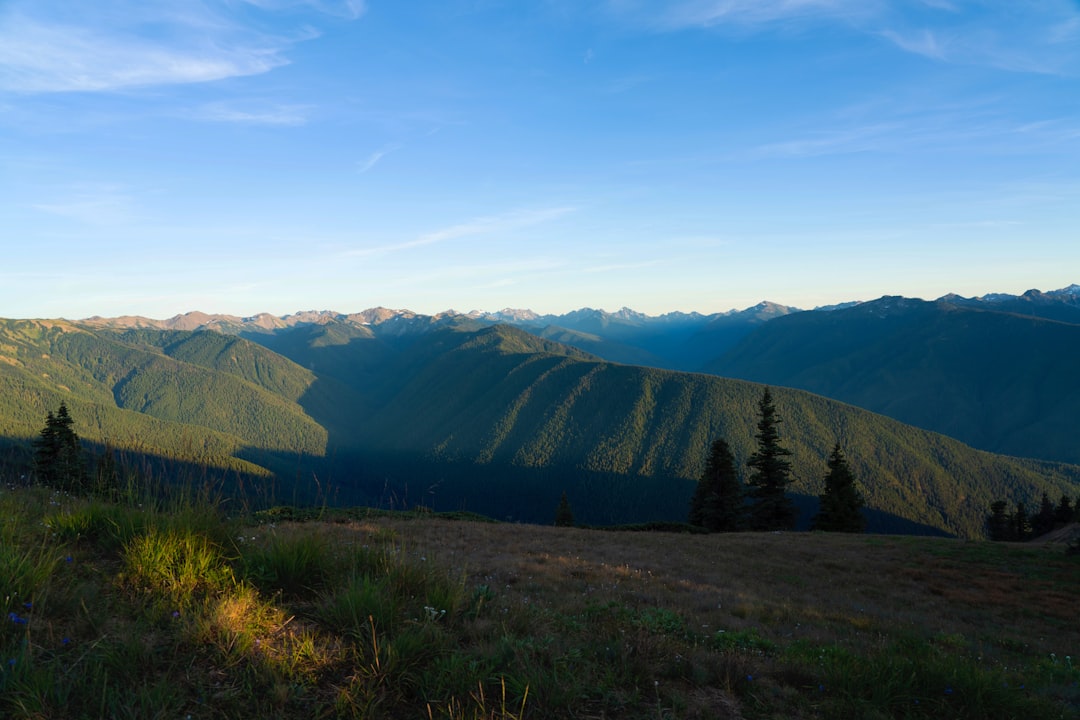
The Olympic Peninsula in Washington State is a true gem, offering visitors a chance to explore its stunning natural beauty through a variety of iconic road trips.
Discovering the Olympic Peninsula's Coastal Treasures
The Olympic Peninsula in Washington State is a true gem, offering visitors a chance to explore its stunning natural beauty through a variety of iconic road trips.
One such route is the Olympic Coast Highway, a 329-mile journey that takes travelers through charming coastal towns, past picturesque beaches, and into the heart of the region's lush temperate rainforests.
The Olympic Peninsula is home to the longest saltwater fjord in the contiguous United States, the Hood Canal, which stretches over 50 miles and was carved by glaciers during the last ice age.
The Hoh Rainforest, located within Olympic National Park, is one of the few remaining intact temperate rainforests in the world and is known for its lush, green vegetation and diverse ecosystem.
The beaches along the Olympic Peninsula's coast are composed primarily of sand and gravel, with the sand being sourced from the erosion of the nearby mountains over thousands of years.
The Olympic Mountains, which dominate the landscape of the peninsula, were formed by the subduction of the Juan de Fuca tectonic plate under the North American plate, creating a geologically active region prone to earthquakes and volcanic activity.
The coastal towns along the Olympic Peninsula, such as Forks and Sequim, have a unique microclimate due to the rain shadow effect created by the Olympic Mountains, resulting in drier and sunnier conditions compared to other parts of the region.
The waters of the Pacific Ocean along the Olympic Peninsula's coast are home to a diverse array of marine life, including orcas, gray whales, and numerous species of seabirds, which can be observed by visitors during whale watching tours and wildlife viewing excursions.
Tracing the Historic Lewis and Clark Trail
Tracing the Historic Lewis and Clark Trail through Washington State offers travelers a unique opportunity to explore the rugged landscapes and diverse ecosystems that captivated the expedition's members over 200 years ago.
The designated auto tour routes along the trail provide access to interpretive centers, monuments, and historical markers, shedding light on the lives and experiences of the explorers and the Native American tribes they encountered.
From the arid beauty of the Okanogan region to the dramatic cliffs and waterfalls of the Columbia River Gorge, these road trips showcase the state's natural wonders and historical significance.
The Lewis and Clark National Historic Trail spans an impressive 4,900 miles, tracing the historic route of the famed 1804-1806 expedition from Pittsburgh, Pennsylvania, to the Columbia River in Oregon.
The trail passes through the homelands of over 60 Tribal nations, offering visitors a unique opportunity to learn about the diverse indigenous cultures that inhabited the regions traversed by Lewis and Clark.
With over 6,600 miles of designated auto tour route, the Lewis and Clark Trail provides a diverse array of recreational, interpretive, and educational experiences for travelers, from historical sites and monuments to stunning natural landscapes.
The Lewis and Clark Trail is home to numerous interpretive centers, museums, and historical markers that provide valuable insights into the lives, experiences, and challenges faced by the legendary explorers and the Native American tribes they interacted with.
Tracing the Lewis and Clark Trail through the state of Washington offers travelers a unique opportunity to explore the diverse landscapes of the region, from the dramatic cliffs and waterfalls of the Columbia River Gorge to the arid beauty of the Okanogan Trail.
The famed Lewis and Clark Trail serves as a framework for a series of iconic road trips through Washington State, each showcasing the state's rich history, stunning natural scenery, and opportunities for cultural and historical exploration.
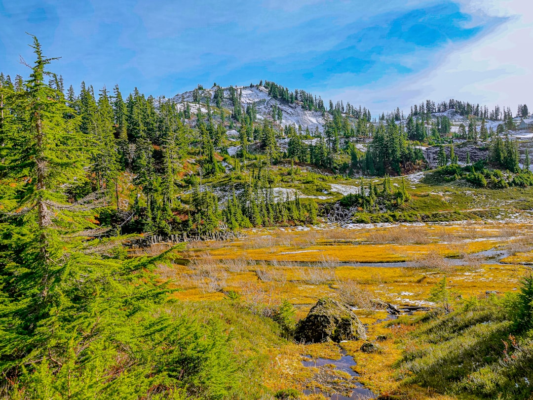
Embracing Nature's Grandeur on the Cascade Loop
the Stevens Pass Greenway, North Cascades Highway, and the Whidbey Scenic Isle Way.
The Cascade Loop spans 440 miles and can be completed in 7-8 hours, depending on the starting point, offering a diverse array of landscapes and outdoor activities along the way.
the Stevens Pass Greenway, North Cascades Highway, and Whidbey Scenic Isle Way, each showcasing the region's unique natural beauty.
The Methow Valley, located along the Cascade Loop, is known for its rugged beauty, featuring a patchwork of sagebrush, farmlands, and the meandering Methow River.
The loop's charming towns, such as Leavenworth, offer opportunities to indulge in local cuisine, explore farmers' markets, and experience the region's rich cultural heritage.
The Cascade Loop provides access to a variety of outdoor recreational activities, including world-class hiking trails, water sports on pristine lakes, and cycling through picturesque valleys.
Geologically, the Cascade Loop traverses an active tectonic region, where the subduction of the Juan de Fuca plate under the North American plate has created a diverse landscape of mountains, volcanoes, and seismic activity.
The loop's unique microclimate, influenced by the rain shadow effect of the Cascade Mountains, results in drier and sunnier conditions in certain regions, offering a distinct contrast to the typically wet and temperate climate of the Pacific Northwest.
Chuckanut Drive - A Coastal Gem Unveiling History
Chuckanut Drive, a 24-mile scenic byway hugging the sandstone cliffs of the Chuckanut Mountains, offers breathtaking views of Samish Bay and the surrounding landscape.
Completed in 1896, this historic road is often referred to as Washington's own "Big Sur," winding through lush evergreen forests, emerald bays, and providing a glimpse into the state's rich past.
The drive is a popular destination for nature enthusiasts and foodies alike, with opportunities to savor fresh local seafood and explore the charming Victorian-era town of Fairhaven.
Despite its winding and sometimes narrow nature, Chuckanut Drive remains a must-see attraction for anyone exploring the scenic landscape of Washington State.
Chuckanut Drive is one of the oldest scenic byways in the United States, having been completed in 1896, over 125 years ago.
The road's name, "Chuckanut," is derived from the local Lummi Tribe's word for "high, rocky land jutting into the sea," reflecting the area's dramatic coastal geography.
The sandstone cliffs along Chuckanut Drive are part of the Chuckanut Formation, a geological feature dating back 50 million years to the Eocene epoch, when this region was a subtropical environment.
Despite its winding and narrow nature, Chuckanut Drive was one of the first highways in Washington State designed specifically for automobile travel, featuring wide shoulders and gentle curves.
The picturesque Fairhaven district, which the drive passes through, was once a separate city from Bellingham and had a thriving commercial district in the late 19th century.
Despite its popularity, Chuckanut Drive remains a relatively undeveloped and unspoiled stretch of coastline, thanks to the efforts of conservationists and land managers to preserve its natural beauty.
Mount Rainier Scenic Byway - Majestic Mountain Vistas
The Mount Rainier Scenic Byway offers a journey through the northeast corner of Mount Rainier National Park, showcasing diverse landscapes from open views of talus and basaltic rock formations in the east to dense forest and vegetative cover in the west.
This byway is a part of the premier driving tour in Washington State, traveling through the Mt.
Baker-Snoqualmie National Forest and Mount Rainier National Park, and traversing the Cascade Mountains, passing by Mount Rainier, old-growth temperate rainforests, waterfalls, and impressive vistas.
The Mount Rainier Scenic Byway traverses the northeastern corner of Mount Rainier National Park, providing access to diverse landscapes ranging from open talus slopes and basaltic rock formations in the east to dense, old-growth temperate rainforests in the west.
The byway's route follows the course of the Naches River, a glacier-fed waterway that carves through the Cascade Mountains, offering dramatic views of the river's turquoise-colored waters.
The byway's highest point, at an elevation of 5,430 feet, offers panoramic vistas of the iconic Mount Rainier, the most glaciated peak in the contiguous United States, with its impressive summit rising over 14,000 feet above sea level.
The byway's eastern section passes through the Okanogan-Wenatchee National Forest, home to the largest contiguous stand of old-growth ponderosa pine in the world, some of which are over 500 years old.
Geologically, the Mount Rainier Scenic Byway traverses an active subduction zone, where the Juan de Fuca tectonic plate is being pushed under the North American plate, resulting in a landscape prone to earthquakes and volcanic activity.
The byway's western terminus in the town of Enumclaw is home to the Enumclaw Plateau, a unique geological feature formed by the deposition of volcanic ash and lahars (volcanic mudflows) from past eruptions of Mount Rainier.
Along the byway, visitors can explore a network of hiking trails that provide access to stunning waterfalls, such as the 368-foot-tall Comet Falls, one of the tallest waterfalls in the Mount Rainier National Park.
The byway's route passes through the Naches River Valley, a region with a rich agricultural history, where farmers have been growing a variety of crops, including apples, pears, and hops, for over a century.
The byway offers access to the White River, a glacier-fed stream that is home to a diverse array of aquatic life, including the iconic bull trout, a threatened species that thrives in the cold, clear waters of the Cascade Mountains.
Mount Baker's Volcanic Splendor on the Scenic Byway
The Mount Baker Scenic Byway provides a remarkable driving experience, featuring picturesque landscapes, towering mountains, and breathtaking views.
Notably, Artist Point, the endpoint of the byway, offers panoramic vistas of Mount Baker and its surroundings, making it a popular destination for photographers and nature enthusiasts alike.
Mount Baker, a Stratovolcano in the North Cascades Range, stands at an impressive elevation of 10,781 feet (3,286 meters), making it the third-highest peak in Washington State.
The Mount Baker Volcanic Field, which encompasses Mount Baker and its surrounding area, is considered one of the most active volcanic regions in the Cascade Range, having experienced numerous eruptions and lahars (volcanic mudflows) over the past 10,000 years.
The Mount Baker Scenic Byway traverses through the Mount Baker-Snoqualmie National Forest, which is home to more than 3,000 glaciers, the highest concentration of glaciers outside of Alaska in the contiguous United States.
The scenic byway passes through the Nooksack River watershed, which is known for its diverse array of spawning salmon, including Chinook, coho, and sockeye, that are an essential part of the local ecosystem and Native American cultural traditions.
The byway's endpoint at Artist Point, situated at an elevation of 5,140 feet (1,566 meters), offers panoramic views of Mount Baker's dramatic glaciers and the surrounding North Cascade peaks, making it a popular destination for photographers and outdoor enthusiasts.
The geological history of the Mount Baker region can be traced back to the Pleistocene epoch, when glacial processes carved out the dramatic U-shaped valleys and cirques that characterize the landscape along the scenic byway.
The Mount Baker Ski Area, located at the end of the scenic byway, is one of the snowiest ski resorts in the world, with an average annual snowfall of over 600 inches (15 meters), thanks to the region's unique orographic lift effects.
The Mount Baker Scenic Byway traverses through the traditional territories of the Lummi, Nooksack, and Skagit tribes, who have inhabited the region for thousands of years and continue to play a vital role in the area's cultural heritage and environmental stewardship.
The byway's diverse ecosystems support a wide range of wildlife, including the iconic grizzly bear, which was recently reintroduced to the North Cascades region after being locally extirpated in the early 20th century.
The byway's geology is characterized by the presence of ancient volcanic intrusions, such as the dramatic basalt columns and talus slopes that can be observed along the route, providing insights into the region's dynamic tectonic history.
San Juan Islands Loop - Where Wine, Whales, and Wonder Converge

The San Juan Islands in Washington State offer a unique blend of natural beauty, outdoor adventures, and culinary experiences.
The San Juan Islands loop provides a well-rounded and picturesque road trip through this scenic corner of the Pacific Northwest.
The San Juan Islands are home to over 200 bird species, including the tufted puffin, a seabird known for its distinctive colorful beak and unique nesting habits in underground burrows.
The islands' waters are a prime habitat for the elusive Pacific harbor porpoise, the smallest cetacean found in the Salish Sea, which can be spotted by keen-eyed visitors during boat tours.
The San Juan Islands are a geologically unique archipelago, formed by the retreat of glaciers during the last ice age, leaving behind a landscape of rocky outcrops, coastal bluffs, and glacial valleys.
The Salish Sea, which surrounds the San Juan Islands, is one of the most biologically diverse inland seas in the world, supporting a rich ecosystem of marine life, including nearly 250 species of fish.
Lime Kiln Point State Park on San Juan Island is considered one of the best land-based locations in the world for observing orcas, with over 80 resident orcas regularly sighted in the park's waters.
The San Juan Islands are home to the world's largest population of Steller's sea lions, a threatened species that can grow up to 2,500 pounds and are known for their distinctive roaring vocalizations.
The San Juan Islands are a designated International Dark Sky Park, offering visitors exceptional stargazing opportunities due to the lack of light pollution, with the Milky Way often visible on clear nights.
The islands' temperate climate and fertile soils have made them a prime location for the cultivation of a variety of agricultural products, including award-winning wines, artisanal cheeses, and organic produce.
The San Juan Islands are a haven for kayakers, with over 400 miles of shoreline to explore, offering opportunities to spot marine life, such as seals, otters, and bald eagles, up close.
The islands' unique geological history has resulted in the formation of several rare mineral deposits, including the vibrant green epidote crystals found at Patos Island.
The San Juan Islands are home to the largest population of the Mazama pocket gopher, a small burrowing mammal that plays a crucial role in the islands' ecosystems by aerating the soil and providing food for predators.
The San Juan Islands are a popular destination for geoturism, with visitors drawn to the region's diverse rock formations, including the distinctive basalt columns and glacial erratics scattered throughout the landscape.
Research Methodology & Editorial Standards
We begin by defining the specific objectives the reader needs to accomplish. Primary product documentation and authoritative secondary sources are assembled into a verified research corpus; drafting occurs only after this foundation is in place.
Every quantitative claim is subjected to dual-source verification. Any figure that cannot be independently corroborated is either qualified or omitted.