Gunnison's US 50 Bridge Closure A Detour into the Heart of Western Colorado's Scenic Routes
Gunnison's US 50 Bridge Closure A Detour into the Heart of Western Colorado's Scenic Routes - Gunnison's Scenic Detour - A Journey through the Heart of Western Colorado
With the closure of the US 50 bridge west of Gunnison, Colorado, travelers are being encouraged to explore the scenic alternative routes in the region.
The detour, which is expected to open on April 22nd, 2024, will allow local residents from Gunnison, Montrose, and Hinsdale counties to reach essential destinations.
While the full extent of the bridge damage and repair timeline remains unknown, this disruption presents an opportunity for visitors to discover the breathtaking landscapes and hidden gems of Western Colorado.
From winding mountain roads to picturesque small towns, the detour promises to deliver a truly memorable journey through the heart of this stunning region.
The US 50 bridge near Gunnison, Colorado, known as K07B, spans the Blue Mesa Reservoir and has been closed since April 18, 2024, due to safety concerns after inspectors discovered cracks in the structure.
The bridge closure has resulted in significant traffic disruptions for travelers between Montrose and Gunnison Counties, with CDOT and the Federal Highway Administration working to identify a path forward for temporary repairs.
A local detour around the bridge closure is expected to open on April 22, 2024, allowing only residents of Gunnison, Montrose, and Hinsdale counties to access work, school, and medical care, while other travelers are advised to use alternate routes such as Interstate 70 or US
Interestingly, the bridge closure has created an opportunity for a "Scenic Detour" through the heart of Western Colorado, offering travelers a chance to explore the region's breathtaking landscapes and lesser-known attractions.
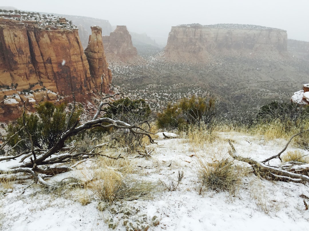
The Gunnison area is known for its diverse geology, with the nearby Dillon Pinnacles formation showcasing intricate volcanic structures that have been carved by wind and water over millennia.
Despite the inconvenience of the bridge closure, the Scenic Detour through Western Colorado's rugged terrain and picturesque valleys presents an opportunity for adventurous travelers to discover hidden gems and off-the-beaten-path experiences that may have otherwise been overlooked.
Gunnison's US 50 Bridge Closure A Detour into the Heart of Western Colorado's Scenic Routes - The Blue Mesa Reservoir - Navigating around Nature's Bounty
The closure of the US 50 bridge west of Gunnison, Colorado, due to safety concerns has led to a significant detour for commuters and locals.
The detour, approved by the Colorado Department of Transportation (CDOT), involves navigating a dirt county road around the damaged bridge, causing longer travel times and disrupting daily routines.
Despite the inconvenience, this detour presents an opportunity for travelers to explore the breathtaking landscapes and hidden gems of Western Colorado, showcasing the region's diverse geology and natural wonders.
As CDOT works to identify a path forward for temporary repairs, the local community continues to adapt to the bridge closure, demonstrating the resilience of this scenic corner of the state.
The Blue Mesa Reservoir is the largest body of water in Colorado, covering an area of over 20 square miles and holding up to 940,000 acre-feet of water when full.
The striking blue hue of the reservoir's water is due to the fine glacial silt suspended in the water, which reflects sunlight and gives the lake its distinctive color.
The reservoir was formed in 1966 with the construction of the Blue Mesa Dam, which stands at 390 feet tall and is one of the highest concrete arch dams in the United States.
The Blue Mesa Reservoir is home to a thriving population of lake trout, which can grow to impressive sizes, with some individuals weighing over 30 pounds.
The reservoir's depth can reach up to 300 feet in some areas, making it a popular destination for scuba diving, with several submerged structures and shipwrecks to explore.
The Blue Mesa Reservoir is a critical component of the Colorado River Storage Project, providing water storage and hydroelectric power generation for the region.
Despite its remote location, the Blue Mesa Reservoir attracts over 1 million visitors each year, drawn to its exceptional fishing, boating, and other water-based recreational activities.
Gunnison's US 50 Bridge Closure A Detour into the Heart of Western Colorado's Scenic Routes - Exploring Crawford and Hotchkiss - Charming Towns Along the Detour Route
Crawford and Hotchkiss, two small towns in western Colorado, offer visitors a unique glimpse into the region's rural charm and scenic beauty along the detour route prompted by the Gunnison's US 50 bridge closure.
With the bridge closure creating a detour through this picturesque area, visitors now have the chance to discover the historic attractions, natural wonders, and community character that define these charming Colorado towns.
Crawford was originally established in 1882 as a stagecoach station along the Ouray to Gunnison route, serving as a crucial transportation hub for the region.
Hotchkiss is home to the Black Canyon Cidery, which produces award-winning hard ciders using local apples and pears, showcasing the town's agricultural heritage.
The Hotchkiss National Fish Hatchery, established in 1937, is one of the largest trout hatcheries in Colorado, annually stocking millions of fish into the state's waterways.
Crawford State Park features a network of hiking trails that wind through the unique geological formations known as the "hoodoos," created by millions of years of erosion and weathering.
The Hotchkiss area is home to several abandoned silver and gold mines, which provide a glimpse into the region's rich mining history and the challenges faced by early prospectors.
The Needle Rock Formation, located just outside of Crawford, is a striking geological feature that has been used as a natural landmark for centuries, guiding travelers through the rugged terrain of the region.
Gunnison's US 50 Bridge Closure A Detour into the Heart of Western Colorado's Scenic Routes - The Gunnison Gorge - A Breathtaking Geological Wonder Revealed
The closure of the US 50 bridge near Gunnison, Colorado has opened up a unique opportunity for travelers to explore the breathtaking Gunnison Gorge, a geological marvel carved by the forces of nature over millennia.
Visitors can now discover the Gunnison Gorge's intricate volcanic structures, dramatic landscapes, and hidden natural gems along the scenic detour routes through Western Colorado.
The Gunnison Gorge is home to one of the deepest river canyons in the United States, reaching depths of over 2,000 feet in some sections.
The exposed rock layers within the gorge date back millions of years, with the oldest formations originating from the Precambrian era, over 2 billion years ago.
The Gunnison River, which flows through the heart of the gorge, is known for its crystal-clear waters and is a popular destination for whitewater rafting and kayaking enthusiasts.
The Gunnison Gorge National Conservation Area, which encompasses the gorge, is home to over 200 species of birds, including the elusive peregrine falcon and the majestic golden eagle.
The unique geological formation known as the "Dillon Pinnacles" can be found within the Gunnison Gorge, showcasing intricate volcanic structures that have been carved by wind and water over millions of years.
The Gunnison Gorge is a designated Dark Sky Park, offering visitors the opportunity to witness breathtaking night sky displays with minimal light pollution.
The Gunnison Gorge is a popular destination for hikers and backpackers, with the Gunnison Gorge Wilderness Area offering challenging trails and remote campsites.
The Gunnison Gorge is home to a thriving population of native trout species, including the Colorado River cutthroat trout, which is considered a threatened species in the region.
The Gunnison Gorge is a part of the Gunnison River watershed, which is a critical source of water for the surrounding communities and plays a vital role in the regional ecosystem.
Gunnison's US 50 Bridge Closure A Detour into the Heart of Western Colorado's Scenic Routes - Curecanti National Recreation Area - Outdoor Adventures Await on the Detour
Curecanti National Recreation Area offers a range of outdoor activities for visitors, including hiking, boating, kayaking, camping, fishing, and wildlife watching.
The recreation area features three reservoirs - Blue Mesa, Morrow Point, and Crystal - providing ample opportunities for water-based recreation.
Despite the inconvenience of the US 50 bridge closure, the scenic detour through Curecanti National Recreation Area allows travelers to discover the area's natural beauty and hidden gems.
The Curecanti National Recreation Area is home to the deepest body of water in Colorado, the Blue Mesa Reservoir, which can reach depths of up to 300 feet.
The striking blue color of the Blue Mesa Reservoir is due to the presence of fine glacial silt suspended in the water, which reflects sunlight and gives the lake its distinctive hue.
The Curecanti National Recreation Area is a popular destination for scuba diving, with several submerged structures and shipwrecks to explore in the Blue Mesa Reservoir.
The Curecanti Creek Trail, a 4-mile round-trip hike, offers hikers stunning vistas of the Curecanti Needle, a unique geological formation that has been carved by wind and water over millions of years.
The Curecanti National Recreation Area is home to a thriving population of lake trout, some of which can weigh over 30 pounds, making it a prime fishing destination for anglers.
The Curecanti National Recreation Area is situated along the West Elk Loop Scenic Byway, a 205-mile route that takes travelers through some of the most picturesque countryside in Western Colorado.
The Curecanti National Recreation Area was established in 1965, making it one of the younger National Park Service units in the United States.
The Curecanti Needle, a striking geological feature within the recreation area, is a popular destination for rock climbers and mountaineers, who are drawn to its challenging terrain and stunning views.
The Curecanti National Recreation Area is home to the Dillon Pinnacles, a unique volcanic formation that has been carved by wind and water over millions of years, creating a series of intricate spires and ridges.
The Curecanti National Recreation Area is a critical component of the Colorado River Storage Project, providing water storage and hydroelectric power generation for the region.
Gunnison's US 50 Bridge Closure A Detour into the Heart of Western Colorado's Scenic Routes - Historic Byways - Discovering Colorado's Rich Heritage Along the Alternate Route
The closure of the US 50 bridge in Gunnison, Colorado has opened up the opportunity for travelers to explore the state's historic byways and scenic routes, showcasing Colorado's rich natural beauty and cultural heritage.
These byways, which include National Forest Scenic Byways and Bureau of Land Management Back Country Byways, offer diverse experiences ranging from the gritty history of the Royal Gorge Bridge to the majestic landscapes of the Rocky Mountains.
By taking the scenic detour, visitors can discover hidden gems, abandoned mines, and ghost towns, as well as connect with the state's past through historical landmarks and landmarks.
The state of Colorado features 26 scenic and historic byways, including 10 National Forest Scenic Byways and 2 Bureau of Land Management Back Country Byways, offering diverse experiences for travelers.
The Colorado Scenic and Historic Byways program covers 2,565 miles across 48 counties, connecting historic sites, parks, and points of interest throughout the state.
The Alpine Loop is a 4x4-recommended byway with high-elevation 1880s roads, wildflower-filled meadows, abandoned mines, and ghost towns, providing a unique glimpse into Colorado's rugged past.
The San Juan Skyway is a 236-mile journey through historic mining towns and mountain passes, showcasing the state's rich mining heritage.
The Cache la Poudre–North Park byway offers a route alongside one of America's few Wild and Scenic Rivers, highlighting granite canyon walls and historic landmarks.
The Gunnison Gorge National Conservation Area, accessible via the scenic detour, is home to one of the deepest river canyons in the United States, reaching depths of over 2,000 feet.
The exposed rock layers within the Gunnison Gorge date back to the Precambrian era, over 2 billion years ago, providing a unique geological window into the distant past.
The Curecanti National Recreation Area, located along the scenic detour, features the deepest body of water in Colorado, the Blue Mesa Reservoir, which can reach depths of up to 300 feet.
The striking blue color of the Blue Mesa Reservoir is due to the presence of fine glacial silt suspended in the water, which reflects sunlight and gives the lake its distinctive hue.
The Curecanti National Recreation Area is a popular destination for scuba diving, with several submerged structures and shipwrecks to explore in the Blue Mesa Reservoir.
The Gunnison Gorge is a designated Dark Sky Park, offering visitors the opportunity to witness breathtaking night sky displays with minimal light pollution, a unique experience for stargazers.